Become a member
Join today and help protect nature, beauty and history – for everyone, for ever. Enjoy access to more than 500 places with National Trust membership.
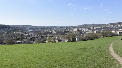
Wide open space overlooking the World Heritage City of Bath
South East of the city of Bath, Bath and NE Somerset

| Asset | Opening time |
|---|---|
| Countryside | Dawn - Dusk |
Dogs on leads near grazing cattle and sheep.
No allocated car park. Some steps with steep and uneven surfaces in part.
Find the 24 doors in the Woodland Play Area this Christmas. The doors show insects, fungi, birds, wildflowers and more things commonly found around the Bath Skyline. Created by rangers and volunteers.

Bath Skyline is a one pawprint rated place. Discover spectacular views of the surrounding countryside and long walks for dogs and owners, no matter what the season. Find out more to help you enjoy your visit.

A circular 6-mile walk around the Bath Skyline, through wildflower meadows, woodland and farmland, with views out over the World Heritage Site.
A circular 3-mile trail from the city centre out to the Bath Skyline.
An accessible 2-mile circular trail around Claverton Down, along woodland paths, and through wildflower meadows. Just follow the red arrows.
A play area in the woods with magical doors for the whole family to enjoy.
There's history beneath our feet with prehistoric flints, Samian pottery, Roman coins and evidence of Roman roads and burials.
A 'green corridor' linking Batheaston and the city of Bath along the River Avon.
An Iron Age hillfort on the north east of Bath with views across Bath and Batheaston.
With 500 acres of woodland and farmland in our care at the Bath Skyline, there's plenty to explore. Discover nature, wildlife and views of the historic city from this natural viewpoint.

A 6-mile circular walk, just a short stroll from Bath city centre. Enter another world in the skyline hills above Bath, through meadows and ancient woodlands to secluded valleys.

A 3-mile circular walk from Bath city centre out to the countryside of the Bath Skyline. Stunning views, hidden waterways and Georgian history await families and explorers.


In the centre of Lacock village, this 15th-century cottage is packed full of charm and makes a cosy base for exploring Lacock Abbey and the countryside nearby.
Find the 24 doors in the Woodland Play Area this Christmas.
Explore the Bath Skyline along miles of waymarked footpaths. There is the Walk to the view - a circular three miles from the city centre out to the countryside and back, a circular 2 miles around the Family Discovery Trail, accessible for pushchairs and wheelchairs, or the full six miles of the ever-popular Bath Skyline walk.
Discover hidden valleys, rich in limestone flowers and tranquil beech woodlands, interspersed with extensive views over Bath.
The limestone grassland slopes support a variety of plants and attract a number of butterflies, great for some spring and summer wildlife spotting.
Away from the main Bath Skyline walk, the Iron Age fort on Little Solsbury Hill offers the perfect vantage point for spectacular views over Bath. The skylark has also made its home here. Listen out for their distinctive song, a warbling of short trills, in late spring.
From springheads and stone markers to Iron Age field systems, learn about the archaeological remains found at the Bath Skyline. Find out how the area was used by the people that lived here.

Bath Skyline relies on its volunteers to help care for the land, from maintaining hedges, litter picking and supporting visitors. To find out if there are roles available, simply search 'Bath' using the link below.


Join today and help protect nature, beauty and history – for everyone, for ever. Enjoy access to more than 500 places with National Trust membership.
By sharing your email address you’re agreeing to receive marketing emails from the National Trust and confirm you’re 18 years old or over. Please see our for more information on how we look after your personal data.