Skip to content
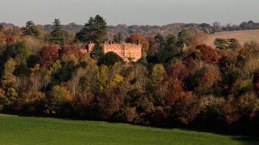
View of Hambleden Village
The Chilterns countryside | © National Trust Images / Hugh Mothersole
Oxfordshire, Buckinghamshire & Berkshire

Hambleden and Pheasant’s Hill trail

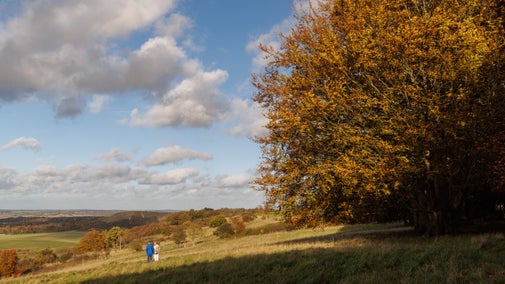
This circular 5-mile walk starts and ends in the flint and red-brick village of Hambleden, taking in the beech woods of the Hambleden Valley and the hamlet of Pheasants Hill while offering great views across the valley.

Restrictive covenants

Some of the land in this walk is protected by the Greenlands restrictive covenant. This is a legal agreement dating from 1944 between the National Trust and Lord Hambleden, which means the land is protected in perpetuity. The land has various private owners, but any changes to the land or the buildings require the prior consent of the National Trust. The route follows public rights of way, including parts of the Chiltern Way. Please always follow the Countryside Code.

Total steps: 12

Total steps: 12

Start point

Pay-and-display public car park at Hambleden village. Grid ref: SU785865. Postcode: RG9 6RP.

Step 1

From the car park, head away from the road entrance towards a footpath signpost by a gate that leads to the cricket ground. Here, turn left along the edge of the field towards a gap in the hedge by some benches and in front of Kenricks – a large house overlooking the cricket ground.

Step 2

Walk through the gap in the hedge then turn left onto a broad track. You'll soon meet a lane where you'll turn right, heading uphill past the entrance to Kenricks. (Ignore the 'No Through Road Private Access' sign – this does not apply to pedestrians following the public footpath). As the lane gives way to a footpath, continue uphill through the woodland until you reach a gate at the top of the hill. Continue straight ahead on a track, passing a large farmyard on your right.

Step 3

Take the next track on your left signposted 'The House', which takes you past the modernised farm buildings of Hutton Farm on your right. Once you've passed Hutton Farm, continue almost straight ahead at a junction, following a rough lane through a double gate with a hedge on your right and views across the Hambleden Valley on your left. After the track starts to slope downhill and enters a wood, take a sign-posted footpath on your left. The path heads downhill through North Close Copse. Keep right at a fork following the yellow footpath marker and continue downhill until you reach the edge of the wood. Here the path turns right between two fields with views of the Hambleden Valley and the hamlet of Pheasant’s Hill on your left. The path eventually emerges onto a narrow road at Rockwell Hill End. Take great care at this point as you may not be seen by cars approaching from the left. Cross the road and turn left, then follow the road downhill into the Hamlet of Pheasant’s Hill.

Step 4

Go past the junction with Bottom Hill on the right then, where the main road bears sharp left by the Lower Mead sign, turn right along a short newly surfaced tarmac lane between houses. After 25 metres, turn left by Appletree Cottage onto a downhill lane between houses. After another 50 metres, turn right following the Chiltern Way sign between a hedge on your right and a private house (Springfield) and garage on your left. You'll soon reach a gate which leads into an open field. Continue until you reach a fourth gate and the quiet lane at Colstrope Farm.

Step 5

Turn left onto Colstrope Lane. Follow the lane for about 250 metres to reach Skirmett Road.

Step 6

Taking great care, bear left across Skirmett Road to reach a light blue wooden gate and follow a path diagonally left across a field towards a group of buildings at Bacres Farm. On reaching the buildings, follow the gravel track in front of the farm which becomes a private road to Built Farm (the road is a public footpath). The road soon turns right and uphill within an avenue of trees. Ignore any side tracks and keep to the signposted footpath until it enters an area of woodland. When you reach a wooden, four-way signpost at the top of the hill, turn left along a level gravel track which meanders through the woodland. Ignore any minor joining tracks or paths. At the next major junction, by a second four-way wooden signpost, turn left again following the track straight ahead across an open area with views into the Hambleden Valley.

Step 7

As the track starts to descend, bear right off the main track onto a woodland path which runs onto a woodland path alongside a fence on your right, through partially cleared woodland and parallel with the track. Descend the hill on this slightly sunken track. (Alternatively, continue downhill on the main track, re-joining the official footpath at the bottom of the slope.) As the path leaves the woodland, turn sharp right and follow the clearly defined path gently uphill. After about 180 metres, bear left off the uphill track and continue straight ahead along a smaller, signposted level footpath ignoring any private forest tracks. You'll catch regular glimpses of the Hambleden Valley and Hambleden village on your left. You'll also pass through a recently restored historic avenue of Wellington trees, which appear to align with the church in Hambleden village. Follow the path for about 1.3km until the path curves to the right and starts heading downhill. Look out for a sign-posted bridleway on the left.

Step 8

Turn left on the bridleway. After a short distance, turn right at a T-junction, still following the bridleway downhill (a large birch tree had fallen across the footpath here when the route was last reviewed) until you reach a wide crossing path at the bottom of the slope. On reaching the path turn left for about 240 metres until you reach a path to the left. Shortly after this, fork right onto a narrower path and head downslope joining a track towards a cluster of buildings and a lane. Follow the short lane until you reach Skirmett Lane.

Step 9

This is a difficult road junction as you cannot be seen easily by the traffic coming from your right. When you judge it to be safe, cross over and turn right along the road for 110 metres. Then turn left onto a rough lane which is also a public footpath. After about 100 metres, turn left through a gate and follow the path across an open field towards Hambleden, which should be clearly visible ahead of you. Note the fine 18th-century barn to your right, which has featured in a variety of television and film productions. The water meadows here are often used for grazing sheep or cattle. After 500 metres you'll reach a gate to the left of a bridge over Hambleden Brook. Turn right, over the bridge, following the road into the village of Hambleden.

Step 10

On reaching the village pump, go straight ahead to reach the lychgate to St Mary the Virgin Church.

Step 11

At the gate, bear half right following a path across the south-east corner of the churchyard to reach another gate. Opposite the gate is an Elizabethan manor house. This is private property – please do not enter the grounds.

Step 12

Turn right on Pheasant’s Hill Road and then almost immediately left. You'll see the Stag and Huntsman ahead of you and, beyond the pub, the entrance to the car park where you started the walk.

End point

Pay and display public car park at Hambleden village. Grid ref: SU785865. Postcode: RG9 6RP

Trail map

A map of the Hambleden and Pheasant’s Hill trail
A map of the Hambleden and Pheasant’s Hill trail | © Crown copyright and database rights 2013 Ordnance Survey

You made it

Share your experience

More near here

Hambleden Mill on the River Thames in Buckinghamshire
Trail
Trail

Hambleden Mill to Henley-on-Thames circular river walk 

This circular Thames walk takes in a historic watermill, the Henley Regatta course, views across the Thames Valley and quiet stretches of river with the chance to spot wildlife.

Activities
Walking
DistanceMiles: 6.1 (km: 9.76)
Tree-bordered fields slope down towards a church and beyond it treetops are visible above a low blanket of mist
Trail
Trail

The best of Coombe Hill walk 

Take a gentle circular stroll to see Coombe Hill highlights on rare chalk grassland, with panoramic views across Aylesbury Vale and Chequers, the prime minister’s retreat.

Activities
Walking
DistanceMiles: 1 (km: 1.6)
A distant view of West Wycombe Park taken from a nearby hill, Buckinghamshire
Trail
Trail

Chiltern Hills three-in-one walk 

Discover a challenging 8½-mile scenic walk linking three National Trust places in the Chiltern Hills: West Wycombe, Bradenham and Hughenden. Longer and shorter routes can be completed depending on your choice.

Activities
Walking
DistanceMiles: 5.5 (km: 8.8) to miles: 8.5 (km: 13.6)
View west from Watlington Hill, Buckinghamshire
Trail
Trail

Watlington Hill short walk 

This walk offers memorable views over the Vale of Oxford and Chiltern Escarpment, as well as abundant wildlife and birdlife amongst the site's chalk grassland and woodland habitats.

Activities
Walking
DistanceMiles: 1.5 (km: 2.4)

Get in touch

Chilterns Countryside, c/o Hughenden estate, High Wycombe, Buckinghamshire, HP14 4LA

Our partners

Cotswold Outdoor

We’ve partnered with Cotswold Outdoor to help everyone make the most of their time outdoors in the places we care for.

Visit website 

You might also be interested in

View to the north from Coombe Hill, showing fields and trees stretching to the horizon
Article
Article

Things to see and do in the Chilterns Countryside 

Discover the countryside sites of the Chilterns. Find the best viewpoints, walk through ancient woodland or pick a quiet spot to watch for wildlife.

Walkers climbing rocks against a bright blue sky with the mountains in the distance at Sugarloaf, Monmouthshire

Walking 

Explore some of the finest landscapes in our care on coastal paths, accessible trails, woodland walks and everything in between. Find the best places to walk near you.

The parterre in spring with Hughenden Manor in the background, Hughenden, Buckinghamshire
Place
Place

Hughenden 

Country home of the Victorian statesman Benjamin Disraeli
High Wycombe, Buckinghamshire

Partially open today
Woodland at Ashridge Estate, Hertfordshire
Place
Place

Ashridge Estate 

Ancient trees, rolling chalk downlands and lush meadows in an area of outstanding natural beauty
Near Berkhamsted, Hertfordshire

Fully open today
A visitor carrying a backpack and walking along a footpath at Divis and the Black Mountain with stone walls either side, the countryside visible in the background.
Article
Article

Follow the Countryside Code 

Help to look after National Trust places by observing a few simple guidelines during your visit and following the Countryside Code.

A group of people in a hiking group are being guided on a hike by rangers at Marsden Moor, West Yorkshire
Article
Article

Cotswold Outdoor: our exclusive walking partner 

Find out more about the National Trust’s ongoing partnership with Cotswold Outdoor as our exclusive walking partner.