Lee Bay to Bull Point circular loop
Devon
This varied circular route takes in sea views, peaceful farm tracks, and a scenic woodland path next to a stream, offering a diverse mix of landscapes and scenery.
Near to
Lee BayStart point
Lee Bay National Trust car park EX34 8LRwhat3words
///beaters.engulfing.complainsTrail information
Difficulty
Full trail
DistanceMiles: 3 (km: 4.8)Total stages: 6
Total stages: 6
Start point
Lee Bay National Trust car park EX34 8LR
Stage 1
From Lee Bay National Trust car park head towards Lee Beach and turn left at the road. Follow the road which will take you up a steep hill. On the corner join the footpath heading out along the South West Coast Path.
Stage 2
Follow the South West Coast path, this will take you past Sandy Cove with lots of undulation and then down a steep zig zag path to Bennett’s Mouth.
Stage 3
Continue along the South West Coast Path which head up a steep slope away from Bennett’s Mouth, keep following this until you reach Bull Point Lighthouse.
Stage 4
At the lighthouse, turn left onto a tarmac road and follow this passing through a stock gate (make sure to close this behind you). Continue straight and at the finger post, follow directions to Damage Barton. This track will take you down a steep windy path to the bottom of the valley.
Stage 5
Turn right and follow the stream through the woods and cross over a footbridge, head up the slope on the other side emerging into fields at the top. Head through a gate and continue straight through the field to another gate. When leaving this field, turn right and head along the track.
Stage 6
At the junction turn left, follow a finger post marked Footpath to Lee and head over the style. Follow this path downhill and up the other side. When you reach the road, continue straight and head down the hill, following the road back to the car park.
End point
Lee Bay National Trust car park EX34 8LR
Trail map
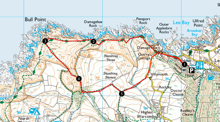
Lee Bay to Bull Point walking map | © Crown copy and database rights 2026 Ordnance Survey

Get in touch
Morte Point and Bull Point circular loop
Enjoy stunning views along the South West Coast Path, a route that is spectacular in both summer and winter. The terrain can be challenging in places, but the effort is well rewarded with sea views and rugged coastal scenery. Keep an eye out for seals, which are often spotted around Morte Point.

Borough Valley and Windcutter hill loop
This walk takes you through the quiet, shady woods of Borough Valley, which come alive with wildflowers in the spring, before climbing through the woodland to the top of Windcutter Hill. It's a scenic and more sheltered alternative to the coast path, with plenty of interest along the way, and passes the Grampus Inn before returning to the car park.

Kinever Valley to Bennett's Mouth
Discover a beautiful hidden cove on this stunning walk along the North Devon coast.
