Bridgewater Monument to Pitstone Windmill circular walk
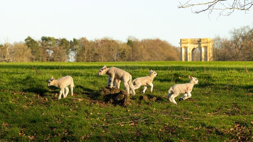
This walk links two great reasons to visit the Ashridge Estate - the Bridgewater Monument and our ancient postmill. You could make it a day out for the whole family. It includes some spectacular views across of the Chilterns and the Vale of Aylesbury, especially if you get the chance to climb the monument.
Please note that this route does include some walking on the road and may not be suitable for families with young children as, in places, crossing can be difficult and there are no verges (see particularly points 4 and 9).

Start:
The Bridgewater Monument, car park, grid ref: SP97001310
1
Stand facing the Bridgewater Monument. This 33-metre-tall tower was erected in 1832 in memory of the Third Duke of Bridgewater, also known as the 'Canal Duke' because of his role in starting the canal-building boom of the late-18th and early-19th centuries. To the right of the Monument there are two paths. Take the one to the right along Duncombe Terrace following a well-surfaced path and signs for mobility vehicles. Follow this path for approximately 1 mile (2km) through woodland until fields begin to appear on your left and you pass a house on your right. At the house go through a gate and turn left onto a track. Continue to follow the track as it bears right, away from the house.
Duncombe Terrace highlights
The bridge you cross after 300m passes over an ancient drover's track historically used by farmers bringing livestock onto the ridge. Further on is a fenced Bronze Age barrow, currently enclosed to prevent damage to the archaeology. Shortly after the barrow is a replica of the Victorian shooting lodge which was destroyed by fire in the 1980s.There are also two cleared viewpoints which are part of a project to reinstate chalk habitats for some of the rare species that live at Ashridge.

2
After approximately 200m you will come to a footpath marker. Turn left off the track, following the boundary trail, onto a footpath which descends gently down the hill and through a gate emerging into a more open landscape. You will find fields to your left and chalk grassland to your right. The fields are separated from the grassland by a thin wire fence. Follow the path to the corner of the field in front of you. When you reach the field continue ahead following the fence line, and keeping it, to your left.
Views of Pitstone Windmill
As the landscape opens out you will be able to see Pitstone Windmill some distance ahead of you. This is a good opportunity to see the windmill in its community context as the villages of Pitstone and Ivinghoe, for which it used to grind flour, can be seen spread out behind it.
3
When you come to a point where two paths form a crossroads, marked by a signpost, continue ahead in the direction signed Ivinghoe. Pass through the gate into a more defined field and continue ahead following footpath signs and the line of a hedgerow, keeping the hedge to your right. When you arrive at a gate in the corner of the field go through it and onto a narrow track which seems to be within the hedgerow. Follow this track to the road.
Chalk landscapes
This section of the route provides spectacular views of Pitstone Hill, Income Hole and the Ivinghoe Hills. These landscapes were formed during the last glaciation as erosion gouged out the chalk, creating a dramatic dry valley at Incombe Hole. More recently Ivinghoe has been sculpted by human occupation and the grassland has been managed to maintain the biodiversity of the landscape. To this end the area is regularly grazed by livestock which prevent the establishment of invasive species which would push out smaller wildflowers.

4
When you reach the road, turn left. CAUTION: this is a very busy road with limited visibility. There is a verge on the left side of the road which you can use but it is uneven so take care. Cross the road where you feel comfortable and continue until you come to the National Trust car park which is near a very tight bend in the road. Cross the car park and go through a gate at the back. You will now be able to see the Pitstone Windmill very clearly. Follow the path directly towards the windmill.
Pitstone Windmill
The Pitstone Windmill is thought to be one of the oldest post mills in Britain. There is a date engraved into its woodwork suggesting that it has been on the site at least since the 17th century. This is now thought to denote a refurbishment of an older mill. Pitstone Windmill ground flour for the villages of Pitstone and Ivinghoe until a freak storm in the early 1900s left it damaged beyond economic repair. Keen to preserve the mill, its owners donated it to the National Trust in 1937 and it has since been faithfully restored by a dedicated team of local volunteers in the 1960s. Please see the website for more information and for opening times.

5
On leaving the Windmill continue across the field to the opposite side to which you entered. When you reach the edge of the field turn left and follow the field margin to the road.
6
Cross the road and turn left. CAUTION: this is a very busy road, there is a verge on the right side of the road but it is uneven in places. Following the road you will eventually come to an opening into a field to your right. Turn in here and then turn immediately left following a narrow track with bushes on both sides. Follow this track as it bends right. Go over a style and continue ahead on the footpath. The footpath winds up hill through bushes following a road, which you can glimpse to your left, before arriving at the edge of a field. When you arrive at a gate go through into the field. Please make sure that if you have a dog it is on a lead and under control as this field is often used for livestock.
7
With your back to the gate go straight ahead passing in front of the hill to your right. Keep an eye out to your left for the National Trust’s Pitstone Hill car park. When you meet the track which comes from the car park and goes up the hill turn right towards the hill. You do not need to climb the hill itself but can take the left fork and walk around the contour, keeping the hill on your right, if you prefer. This lower route soon bears right and begins to run parallel to a fence. Follow the fence to its corner where you will find a sign post.
8
Follow the sign left through the gate into the field. The path skirts the edge of the field for approximately 100m before bearing left across two fields divided by a rough track. When you reach the tree-line beyond these fields turn left and walk around the edge of the field until you come to the road.
9
Turn right and follow the road until you meet a substantial wall to the left and a signpost to your right.
10
Turn left following the sign indicating the Bridgewater Monument. Go through a gate into a stable yard. Keeping the stables on your left cross the yard and continue straight ahead onto a track. Ignoring farm tracks to the right and left you will eventually come to a fork marked by footpath signs.
11
Take the right fork following the purple arrow. The path climbs uphill into woodland. Follow this path until you come to another fork. This time take the left option past the ‘No Horses’ sign. Continue straight ahead through a clearing until you come to a well surfaced track. Turn right onto the track which will bring you back to the Bridgewater Monument.
Monument Green
If you still have the energy you might like to climb the 172 steps of the Bridgewater Monument for panoramic views of the surrounding countryside (check the website for opening times). You can also get a well-earned snack from the Brownlow Café (National Trust approved concession).
End:
The Bridgewater Monument, car park, grid ref: SP97001310