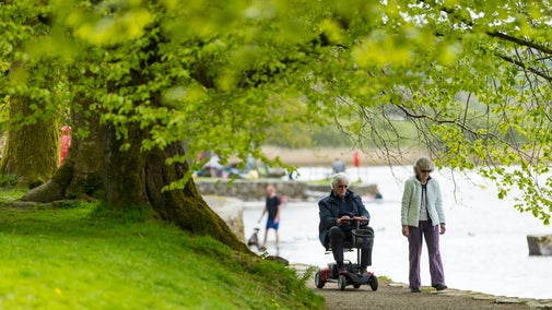
Aira Force to Glencoyne Trail
Lake District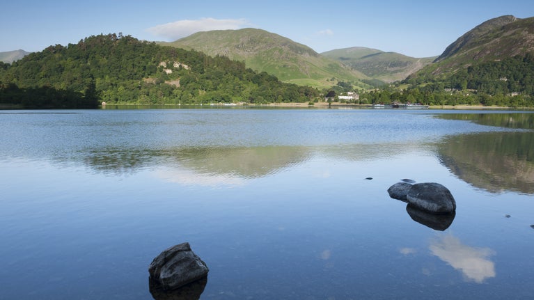
A linear route from Aira Force to Glencoyne along the edge of the Ullswater with views of the lake and fells.
Start point
Aira Force National Trust Car Park, near Watermillock, Penrith, Cumbria CA11 0JS. Grid reference: NY 40082001 what3words: ///shuttle.infants.hikesTrail information
Steep step ups and step downs, short climbs and narrow paths
The largest step up is 4.7in (12cm) from a loose gravel path onto a main road at stop 6. The largest step down is 5.5in (14cm) off a footbridge at stop 20. The longest climb is for 43yd (40m) with an average gradient of 10%. At stop 15, there is a 112ft (34m) uphill climb at 15%. The narrowest path is 2.2ft (70cm) wide at stop 19.
Address
Aira Force National Trust Car Park, near Watermillock, Penrith, Cumbria CA11 0JS. Grid reference: NY 40082001 what3words: ///shuttle.infants.hikes
By busTake the 508 Stagecoach bus service from Penrith to Patterdale. This service terminates at the Patterdale Hotel bus stop during the winter months, and the service extends to Windermere from the start of the Easter holidays until the end of the autumn half-term. Take the 509 seasonal bus service from Keswick to Glenridding.
By trainPenrith station 10 miles (16km) where you can connect to the 508 bus service
By ferryEnjoy a 20-minute cruise from Glenridding to Aira Force on the Aira Force shuttle boat from the end of March until the end of October.
By roadFrom the M6, J40, take the A66, then A592 to Ullswater. Just before the junction with the A5091 is the main car park. From Keswick, the A66 towards Penrith then the A5091 at Troutbeck and follow this to A592 junction. Turn left at the junction, and the main car park is approximately 218 yards (200m) on the left. You will pass two smaller car parks, High Cascades and Park Brow on the A5091. From Windermere, take the A592 over the Kirkstone Pass, going through the villages of Patterdale and Glenridding. Aira Force main car park is approximately 3 miles from Glenridding, just after the junction for the A5091.
- Toilet
Small toilet block close to the main car park entrance. The toilets are open 24 hours a day. All the toilets have baby-changing facilities. Portaloos provided in summer when the site is busy, situated next to permanent toilets. Next closest public toilets situated in Glenridding village (3 miles south on the A592).
- Tea-room
Tea room serving hot and cold drinks, light bites and sweet treats with indoor and outdoor seating. Takeaway available. Additional seasonal outlet open near the Welcome Building during busy times. Drinking water taps around the car park and tea room for people to refill drinking bottles (switched off during cold weather).
Parking There are three disabled parking spaces for Blue Badge holders at the start point. Parking is free for Blue Badge holders. National Trust members please scan your membership card. Non-members please pay to park. Accessible toilet The accessible toilet is next to the men's, adjacent to the car park entrance. There is an uphill ramp of 8% and a small lip in the concrete at the entrance. The toilet is part of the National Key Scheme and is accessed with a radar key. If you need to borrow a key, please speak to one of the team. Gradients This trail has uphill and downhill paths ranging from 2% to 27%. The steepest gradient at 27% runs for 1m on a speed bump type feature towards a wooden gate. This is located at step 6. The longest uphill climb is at stop 8. It is 135yd (124m); the first half at 7% and the second half at 2%. The longest downhill slope is at stop 17 for 151yd (138m), the steepest section at 14%. Surfaces Paths are predominantly loose and coarse gravel. There are protruding rocks along the route. The paths are subject to flooding and at step 17, very muddy where the paths meets a farm track. Steps/uneven surfaces The largest step up is 4.7in (12cm) from a loose gravel path onto a main road at stop 6. The largest step down is 5.5in (14cm) off a footbridge at stop 20. Gates/ bridges There are 7 gates along the route. The widths of the gates range from 3.2ft (98cm) to 4.5ft (140cm). Most gates open away from the user. At stop 18 the gate opens towards the user. It does not open fully and has a width of 2.2ft (70cm). There are 8 wooden bridges along the route. The widths of the bridges range from 3.7ft (115cm) to 4.2ft (130cm).
- Designated parking
There are three disabled parking spaces for Blue Badge holders at the start point. Parking is free for Blue Badge holders. National Trust members please scan your membership card. Non-members please pay to park.
- Accessible toilet
The accessible toilet is next to the men's, adjacent to the car park entrance. There is an uphill ramp of 8% and a small concrete lip at the entrance. The toilet is part of the National Key Scheme and is accessed with a radar key. If you need to borrow a key, please speak to one of the team.
- Steps/uneven terrain
This trail has uphill and downhill paths ranging from 2% to 27%. The steepest gradient at 27% runs for 1m on a speed bump type feature towards a wooden gate. This is located at step 6. Paths are predominantly loose and coarse gravel. There are protruding rocks along the route. The paths are subject to flooding and at step 17, very muddy where the paths meets a farm track.
Gradient
This trail has uphill and downhill gradients ranging from 2% to 27%. The steepest gradient at 27% runs for 1m on a speed bump type feature towards a wooden gate. This is located at step 6. The longest uphill climb is at stop 8. It is 135yd (124m); the first half at 7% and the second half at 2%. The longest downhill slope is at stop 17 for 151yd (138m), the steepest section at 14%.
Surfaces
Paths are predominantly loose and coarse gravel. There are protruding rocks along the route. Paths are prone to flooding and erosion after heavy rainfall. At step 17, it can be very muddy where the paths meets a farm track. There are lots of trees along the trail which will reduce the traction in the Autumn and winter months.
Steps/uneven surfaces
The largest step up is 4.7in (12cm) from a loose gravel path onto a main road at stop 6. The largest step down is 5.5in (14cm) off a footbridge at stop 20.
For further information on the nature of the paths and route itself, please see the trail itself.
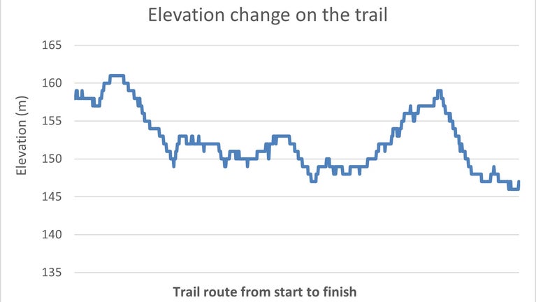
Elevation change on the Aira Force to Glencoyne trail, Aira Force and Gowbarrow Park, Cumbria | © National Trust/ Lucy Baird Total stages: 20
Total stages: 20
Start point
Aira Force National Trust Car Park, near Watermillock, Penrith, Cumbria CA11 0JS. Grid reference: NY 40082001 what3words: ///shuttle.infants.hikes
Stage 1
At the Blue Badge parking spaces, cross over the road and walk towards the information panel and car park machine.
Moving vehicles
The car park is very busy in the summer so be aware of moving vehicles.

Blue Badge parking spaces at Aira Force car park, Aira Force and Gowbarrow Park, Cumbria | © National Trust/ Lucy Baird Stage 2
With the stone wall on your right, walk straight along the path towards the toilet block. The footpath and car park are made of the same material and are hard to tell apart.
Raised drain cover
There is a square raised drain cover on the path. This creates a lip of 0.8in (2cm). This is covered in leaves during the Autumn.

Square drain cover on the footpath to the toilet block, Aira Force and Gowbarrow Park, Cumbria | © National Trust/ Lucy Baird Stage 3
Where the path splits, take the right-hand fork and continue uphill past the toilet block. The path is loose coarse gravel.
Uphill climb
There is a steep uphill climb of 38yd (35m).

Sloping uphill path of coarse gravel towards the tea room, Aira Force and Gowbarrow Park, Cumbria | © National Trust/ Lucy Baird Stage 4
At the tearoom the path bends to the left. The path slopes downhill for 33ft (10m) with a gradient of 8% towards a wooden gate.
Narrow gate
The wooden gate has a pull up latch on the right-hand side. The latch is not clearly visible. The gate opens away from you, and has a width of 3.2ft (98cm).

Wooden gate leaving the Aira Force tea room towards the road, Aira Force and Gowbarrow Park, Cumbria | © National Trust/ Lucy Baird Stage 5
Go through the gate and take the right path at the fork with the wooden signpost on your right. The path material is loose and coarse and there are some protruding rocks. The path slopes downhill for 141ft (43m) with an average gradient of 4%. It narrows to 3.6ft (110cm) where it meets the road.
Large boulders and step up
There are two large boulders in the centre of the path. The width of the path between them is 4.5ft (138cm). Where the path meets the main road, there is a step up of 4.7in (12cm).

4.7in (12cm) step up from the gravel path down from the tea room onto the A5091, Aira Force and Gowbarrow Park, Cumbria | © National Trust/ Lucy Baird Stage 6
Go straight over the road towards the wooden gate. The road is on a camber and can be busy.
Step down onto a downhill slope
There is a step down of 3in (7.5cm) off the road onto a coarse gravel path, with a speed bump type feature. The path has a downhill gradient of 27% for 3ft (1m) to a wooden gate. The gate has an opening of 4.1ft (125cm) and opens away from you. The gate is opened by a metal handle halfway down on the right-hand side.

Sloping gravel path off the A5091 with a wooden gate, Aira Force and Gowbarrow Park, Cumbria | © National Trust/ Lucy Baird Stage 7
The route does not leave this path but does cross over farm access tracks. Stops 8 to 20 highlight different features along the path.
Wooden gate and footbridge
The gate is 4.5ft (140cm) wide with a lever latch halfway down on the right and can be opened either away from you or towards you. After the gate there is a 3ft (1m) uphill bend with a 15% gradient onto the wooden footbridge. There is a 1in (3cm) lip onto the bridge. The bridge is 3.7ft (115cm) wide and 4.92yd (4.5m) long.

Wooden gate with a sharp right turn uphill onto a wooden footbridge, Aira Force and Gowbarrow Park, Cumbria | © National Trust/ Lucy Baird Stage 8
The gate is 4.4ft (135cm) wide with a lever latch halfway down on the left. It can be opened either away from you or towards you. Go through the gate and continue along the path to two wooden gateposts. There is an uphill slope for 135yd (124m). The first half climbs with a 7% gradient. The second half climbs with a 2% gradient.
Steep uphill climb
From the bridge, the path slopes uphill for 43yd (40m) to the gate. The average gradient is 10%. The steepest gradient is 16%.

Uphill sloping loose gravel path from wooden footbridge, Aira Force and Gowbarrow Park, Cumbria | © National Trust/ Lucy Baird Stage 9
The width between the two posts is 4.5ft (140cm). The path slopes downhill for 63yd (58m) at an average gradient of 8%. The gate is 4.3ft (132cm) wide and has a latch halfway down on the left. It can be opened away from or towards you.
Steep drop off
There is a drop off down into a steep banking on the left of the path. At the narrowest point, the path is 4.5ft (140cm) wide.

Downhill sloping path with steep drop off into the banking, Aira Force and Gowbarrow Park, Cumbria | © National Trust/ Lucy Baird Stage 10
The path surface is mainly loose material with some larger and coarser material. For the next 135yd (123m), the path has an average uphill gradient of 4%. The steepest gradient is 9% near stop 11.
Protruding rock
There is a protruding rock of 1.5in (4cm) at the gate threshold.

Loose gravel path with large protruding rock, Aira Force and Gowbarrow Park, Cumbria | © National Trust/ Lucy Baird Stage 11
The bridge is 4.2ft (130cm) wide and 23ft (7m long). There is an uphill climb of 7% for 16.4ft (5m) towards a bench.
Loose, coarse path surface
For 98ft (30m) there are some protruding rocks of 1.5in (4cm) and on the left of the path, it is coarse, loose material. This can be avoided by staying on the right of the path.

Coarse, loose gravel path with some protruding rocks, Aira Force and Gowbarrow Park, Cumbria | © National Trust/ Lucy Baird Stage 12
The path surface is loose gravel with small protruding stones. There is an average uphill gradient of 8%.
Stone culvert across the path
A culvert runs across the width of the path. Inside the culvert there are protruding and loose rocks. There is a 11% downhill gradient for 3ft (1m) into the culvert.

Stone culvert across the loose gravel path, Aira Force and Gowbarrow Park, Cumbria | © National Trust/ Lucy Baird Stage 13
Continue straight ahead and go across the wooden bridge. Here the path slopes downhill for 122yd (112m) with an average gradient of 7%.
Step down off wooden footbridge
There is a 1in (3cm) lip up onto the bridge and a 2.7in (7cm) step down. The bridge is 4.2ft (130cm) wide and 13ft (4m) long. The first board moves when you cross it.

A 2.7in (7cm) step down off the wooden footbridge, Aira Force and Gowbarrow Park, Cumbria | © National Trust/ Lucy Baird Stage 14
The gate is 4.2ft (130cm) wide. It has a lever latch halfway down on the left. It can open away from you or towards you.
Uphill slope with protruding rocks
At the gate, the path climbs for 39ft (12m) with an average gradient of 12%. The path surface is loose gravel with some protruding rocks of 2in (5cm) for a distance of 6.5ft (2m).

Uphill slope with a section of protruding rocks, Aira Force and Gowbarrow Park, Cumbria | © National Trust/ Lucy Baird Stage 15
The bridge is 4.1ft (126cm) wide and 23ft (7m) long. There is a 1in (2.5cm) lip onto it and 0.4in (1cm) step down.
Steep uphill climb and sharp drop off
At the bench, the path climbs round to the right for 112ft (34m). The steepest gradient is 15%. There is a sharp drop off into the banking on the left. The narrowest section of path is 4.9ft (150cm).

A steep uphill climb around a corner with a steep drop off, Aira Force and Gowbarrow Park, Cumbria | © National Trust/ Lucy Baird Stage 16
The path slopes uphill around a corner for 33ft (10m) at 15% onto a wooden bridge. There are protruding rocks of 2in (5cm). There is a 2.3in (6cm) step up onto the bridge with a 2.3in (6cm) step down.

Steep uphill climb around a corner towards a wooden footbridge, Aira Force and Gowbarrow Park, Cumbria | © National Trust/ Lucy Baird Stage 17
The path slopes downhill for 151yd (138m). The steepest gradient is 14%. There are sections of cobble sized stones of 3in (7.6cm) protruding from the path.
Areas of loose, coarse material
The path surface is loose and coarse material. There is a 33ft (10m) section with protruding rocks on the right of the path. At the end of the slope there is exposed path lining.

Downhill slope of loose gravel with exposed path lining, Aira Force and Gowbarrow Park, Cumbria | © National Trust/ Lucy Baird Stage 18
Protruding rocks, tree roots and a fence post narrow the path to 2.7ft (83cm).

A narrow section of path with protruding rocks and a fence post, Aira Force and Gowbarrow Park, Cumbria | © National Trust/ Lucy Baird Stage 19
The bridge is 3.9ft (120cm) wide and 19.6ft (6m) long. It has a step down of 5in (13cm) onto loose material. There is a 16.4ft (5m) downhill slope of 9% into a corner where the fence and stone wall meet.
Narrow opening
The first gate has a latch lever halfway down the gate on the right. It opens towards you but does not open to its full extent. The path width is 2.2ft (70cm).

Narrow wooden gate opening with protruding tree roots on footpath, Aira Force and Gowbarrow Park, Cumbria | © National Trust/ Lucy Baird Stage 20
Turn left onto the second bridge and continue into the car park. There is a downhill slope of 9% onto loose material and protruding rocks. Continue for 33yd (30m) to the car park.
Steep step down
The wooden bridge is old and rotten. It is 3.9ft (120cm) wide and 16.4ft (5m) long. At the far end there is a step down of 5.5in (14cm).

The 5.5in (14cm) step down from the footbridge onto the footpath, Aira Force and Gowbarrow Park, Cumbria | © National Trust/ Lucy Baird End point
Glencoyne National Trust Car Park, Penrith, CA11 0QT. Grid reference: NY38681887 what3words: ///subsystem.dated.seasons
Trail map

Aira Force to Glencoyne route, Aira Force and Gowbarrow Park, Cumbria | © National Trust/Lucy Baird
More near here
Exploring Aira Force and Gowbarrow Park
Find out what Aira Force has to offer, including waterfalls, walks with far-reaching views, ancient woodland, red squirrels, picnic spots and access to the lake.
Accessible walk to Broomhill Point viewpoint
An out-and-back accessible route along Derwent Water lakeshore to the viewpoint at Broomhill Point
Derwent Water and Cockshot wood accessible loop
A short circular accessible route along Derwent Water lakeshore through Cockshot Wood
Fell Foot Park Short Loop
Discover this accessible, circular trail around Fell Foot Park taking in views of the fells from Windermere lakeshore in the Lake District.
