Discover more at The Mournes
Find out how to get to The Mournes, where to park, the things to see and do and more.

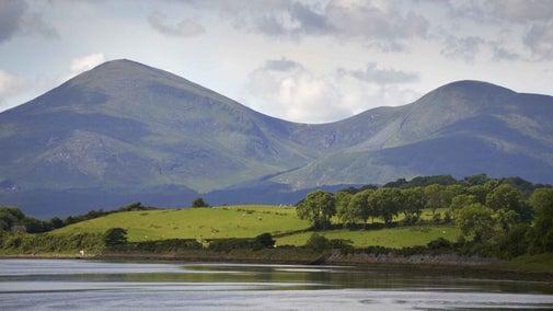
Explore the highest and most dramatic mountain range in Northern Ireland. Beloved by hikers, hillwalkers and cyclists the Mournes have also long inspired songwriters and storytellers, and influenced C.S. Lewis to write ‘The Lion, The Witch and The Wardrobe.’ It's a landmark of international importance, its 12 peaks have been designated as an Area of Outstanding Natural Beauty (AONB) and with miles of footpaths to explore, there's plenty to see and do.
The Mournes have been voted one of Ireland’s favourite walking destinations and it’s easy to see why.
The network of paths and tracks that cross over this mountain range are not all for the faint-hearted, but the views of the valleys, lakes, rivers and reservoirs make it well worth the climb.
We care for 526 hectares of the Mournes, which takes in part of Slieve Donard and Slieve Commedagh and includes Bloody Bridge.
Hugging the County Down coastline, the Mournes structure is made up of 12 peaks that extend into an area only 15 miles by 8 miles (24 x 13 kilometres), each mountain rising above 600m with the highest being Slieve Donard which towers above 852 metres.
The name ‘Bloody Bridge’ refers to a massacre at the site during the 1641 rebellion, when the bodies of slain prisoners were thrown over the bridge into the river turning the water red.
Despite its gory history, the area is one of the most picturesque spots for a walk in the Mournes, and an excellent spot to begin an ascent to Slieve Donard.
This area is particularly steep in points and should only be attempted by experienced walkers. The climb to the summit is strenuous but worth it for the spectacular view over the County Down coast, Newcastle town and Murlough Dunes - and on a clear day you can even see across to Scrabo Tower and the Isle of Man.
Alternatively, the Glen river path leads up to the saddle (or col) between Donard and Commedagh, and the Mourne Wall which is a well-known feature in the Mournes.
If you’re looking for a sea breeze, you can also take a wander along the Mournes coast path. The paths run from the rocky coastline of Dundrum Bay to the lower slopes of the Mourne Mountains, linking ‘true’ mountain with open sea.


Find out how to get to The Mournes, where to park, the things to see and do and more.
Slieve Donard is steeped in history with settlements dating back to 5,500 BC. Named after a hermit who lived on the summit, discover the history of Northern Ireland’s tallest mountain.

Join us as a volunteer ranger in the Mournes mountains and help others enjoy their visit by helping to look after this nationally important place.

We’re carrying out conservation work at the Mournes Mountains in Northern Ireland to help the area recover from damage caused by wild fires and adapt to the effects of climate change. Find out how measures such as conservation grazing, wildlife surveys and new technology are protecting fragile habitats and supporting nature.
Find out how the paths at Slieve Donard are being repaired in the Mourne mountains and discover how the work is funded and how you can help.
Plan a visit to one of the special countryside places in our care and discover the benefits of being in the great outdoors. Pack your walking boots and get ready to explore woodlands, valleys and rivers.

Explore some of the finest landscapes in our care on coastal paths, accessible trails, woodland walks and everything in between. Find the best places to walk near you.

Whether you're looking for a heart-raising hike up Northern Ireland's highest mountain or a ramble by the river at The Argory, there are many countryside and woodland places to experience in Northern Ireland. Enjoy woodland respite at Minnowburn with the forest bathing beds or escape to the wild landscape of County Fermanagh with the countryside adventures at Florence Court, Castle Coole and Crom.
