Pepperbox Hill trail
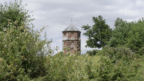
This is a fairly long and moderately challenging walk through woodland, farmland, scrubland and past chalk grassland brimming with butterflies. The route passes the Pepperbox, a 17th-century brick folly which stands at a high point on the chalk escarpment, and which gets its name from a resemblance to a Georgian box used to hold valuable peppercorns. The trail is also rich in birdlife, with bullfinches, green woodpeckers, kestrels and yellowhammers to be spotted.
Total steps: 23
Total steps: 23
Start point
Pepperbox Hill National Trust car park, grid ref: SU211248
Step 1
Park at the Pepperbox Hill car park, just off the A36. Leave the car park via the pedestrian gate in the fence to your left as you drove in. Pause to read the interpretation panel just inside the gate for information about the wildlife you may be able to spot during your walk. Continue straight on along the well-trodden path and The Pepperbox should come into view on your right. Take a detour up to the folly for a closer look, then return and continue along the well-trodden path towards the bench and viewpoint ahead.
Step 2
Just in front of the bench is a viewpoint with an orientation map showing you what features can be seen in the distance ahead of you. Spend a few moments here taking it all in before continuing past the bench on the well-trodden path. The path meanders between some scrubby bushes and then heads towards a large metal gate in the fence ahead.
Step 3
Go through the wooden kissing gate just to the left of the metal gate and head down the slope to the right onto the main byway track. Turn right and continue along the track which can be uneven, muddy and very potholed in places.
Step 4
When you reach a Y-junction with another track, stay left and continue downhill. You should pass a stile halfway down on your left-hand side, on the top of a bank. Pop up to have a look at Grimstead Down, another National Trust property, which is a great spot for finding rare Duke of Burgundy butterflies. Feel free to explore further before continuing on down the hill along the track.
Step 5
At the end of the byway turn right onto the road and walk along it for approximately 80 yards until you see a 'Restricted Byway' sign on your left.
Step 6
Turn left down the byway and continue along this very straight track towards East Grimstead. Go over the railway bridge and continue straight onto the road and over the second bridge, keeping the church on your left.
Step 7
When you reach the first track on your right, opposite Orchard House and just before the right-hand bend, turn right down it alongside some houses. At the end of the track continue straight along the grassy path down to the left-hand side of the house ahead and over the stile at the end. Turn left to cross over the sleeper bridge and climb over the low hurdle gate and into the field. Ignore the waymarker arrow and turn immediately right to follow the fence line to the end of the field. You will see a gate ahead of you on the right: go through it and continue straight on along the well-worn grassy path. The path bears around to the left at the end of the field and you will find a gate in the hedge. Go through it and head diagonally right to the corner of the field.
Step 8
Go through the metal kissing gate in the corner and turn right onto the lane. Continue over the small bridge and head towards the security gates at the end of the concrete road.
Step 9
Pass through the gap to the right-hand side of the gates and turn left onto the road.
Step 10
After approximately 80 yards, turn right just before the buildings into a large gravel driveway and then take the track which leads off straight ahead of you. Go under the railway bridge and carry straight on along the track between the two fields.
Step 11
When you reach the public bridleway sign turn left, cutting diagonally across the field following the visible tracks, towards the right-hand side of the clump of trees ahead. Once at the trees continue on the same diagonal towards the post marked with a white square, visible in the corner of the field.
Step 12
Go through the gap to the left of the post and continue along the track between the fence on your right and the trees on your left. At the end of the track go through the small gate next to the large metal field gate and carry straight on through the small field. Go through the gate at the end, closing and clipping the chain shut behind you. Carry on along the track until you reach the road. Cross straight over the road into the farmyard and turn right, crossing through the yard and onto a track.
Step 13
At the crossroads carry straight on towards the houses in front of you, and then turn right to walk along in front of them. When the gravel drive ends carry straight on along the narrow path, keeping the fence line on your right, and up into the woods ahead. At the fork keep right following the less-obvious overgrown track up the hill. The path here is narrow, overgrown and steep and slippery in places, especially after rain.
Step 14
At what looks like a T-junction with a sunken path, with a steep bank ahead of you, turn right following the path along the hillside.
Step 15
At the crossroads turn left following the path as it turns into a sunken path between two steep banks. At the end of this section follow the path as it climbs out of the hollow onto the left-hand bank and continue straight ahead.
Step 16
When you eventually emerge onto a road, turn right onto it.
Step 17
When the tarmac road bends round to the left, towards barns and houses, carry straight on uphill, along the track signposted as a byway (ignore the bridleway to your right).
Step 18
At the junction with a metal pedestrian gate on your left and a track on your right, carry straight on.
Step 19
At the T-junction turn left, back onto the byway.
Step 20
Shortly after you emerge from the woods you will see a track to the left with two metal field gates visible from the byway. Don't go up here but carry on for another 20 yards along the byway and you will see the gate into Pepperbox Hill up a slope on your left-hand side. Go through the gate and turn right. At the Y-junction formed by two well-trodden paths just beyond the gate, take the left-hand path and follow it, keeping the fence on your left.
Step 21
At the next Y-junction take the left-hand, more well-trodden path, still keeping the fence on your left. Eventually the track will open up into a series of three wild flower areas with scrubby areas between them. Keep left following the path.
Step 22
The path will start to bend round to the right at the end of the reserve, through a large grassland area and then the path straightens out as it heads down towards the A36 which you can hear through the trees ahead of you.
Step 23
Just before you reach the road turn right, along a well-trodden path uphill and continue along this path until you reach the car park.
End point
Pepperbox Hill National Trust car park, grid ref: SU211248
Trail map
More near here
Mottisfont estate walk
HampshireDiscover the beautiful, diverse Mottisfont estate on a varied circular walk through ancient woodlands, historic farmland and Mottisfont village.
A walk around Cathedral Close, Salisbury
While visiting Salisbury, take this walk around the historic Cathedral Close and soak up the atmosphere and history of this special place.
Walk to the Huff Duff
HampshireA circular walk from Ibsley to Rockford Commons, taking in military history with a visit to the Huff Duff (a wartime directional station) and wildlife to spot along the way.
Hale Purlieu figure of eight walk
HampshireA figure of eight walk through Hale Purlieu, crossing streams and taking in great views across the valleys and mires of the New Forest's Northern Commons.
Get in touch
Pepperbox Hill, A36, 6 miles south of Salisbury, Salisbury, Wiltshire, SP5 3QL
Our partners
We’ve partnered with Cotswold Outdoor to help everyone make the most of their time outdoors in the places we care for.
You might also be interested in
Walking
Explore some of the finest landscapes in our care on coastal paths, accessible trails, woodland walks and everything in between. Find the best places to walk near you.
Our work at Pepperbox Hill
Discover how exactly National Trust rangers are helping orchids and butterflies to thrive, with a little help from a hungry herd of local cattle.
Walking in Wiltshire
From walking in the footsteps of King Alfred to exploring the county's mysterious ancient monuments, these are some of the best walks in Wiltshire.
Staying safe at National Trust places
The special places in National Trust care sometimes come with a few risks for visitors, be it coastline or countryside. Find out how to keep safe throughout your visits.
Follow the Countryside Code
Help to look after National Trust places by observing a few simple guidelines during your visit and following the Countryside Code.
Cotswold Outdoor: our exclusive walking partner
Find out more about the National Trust’s ongoing partnership with Cotswold Outdoor as our exclusive walking partner.