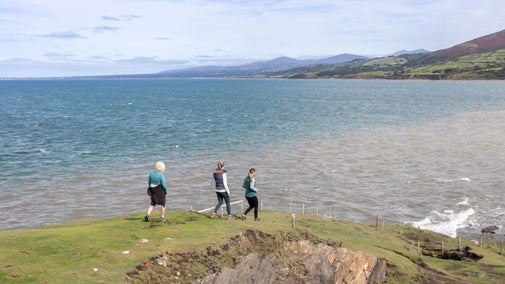
Godrevy to Hell’s Mouth coastal walk
Exhilarating cliff-top pathways and glorious ocean views. This route takes you around Godrevy headland to the dramatic Hell's Mouth and back again, taking in the wonderful heathland of the Knavocks.
Head out through the dunes for ocean views
Learn fascinating local history of shipwrecks and pirates, see if you can spot dolphins, seals and basking sharks in the Cornish waters, and enjoy the wildlife on the colourful heathland.


Start:
Godrevy National Trust car park, grid ref: SW583423
1
From the car park by Godrevy café and the wooden car park hut make your way along the boardwalk through the Towans (Cornish for sand dunes). Catch your first glimpses of St Ives Bay as you head out of the dunes and walk towards the lifeguard hut. Bear right and follow the path along the grassy cliff-top.
Wrecks of St Ives Bay
Imagine this bay once busy with sailing coasters trading to Wales, carrying Cornish slate and copper ore, or returning with coal. Irish vessels would be laden with butter, pork, and linen. Exotic ivory, palm oil and gold dust from Africa, hides and horns from Argentina, coffee and spices from the Dutch East Indies, rum and sugar from West Indies - a busy and noisy bay.
2
Continue along the grassy cliff-top, St Ives Bay opens up on your left and the vast horizon spreads out before you. On the left you can look down to the beach and you will walk past the small parking area on your right.
Godrevy Lighthouse
Standing lonely on the reef known as the Stones, the lighthouse was built in 1859 following outcry due to the loss of all hands aboard the SS Nile, a 700 ton steamer wrecked upon the rocks. At 26m high and with a range of 12 miles (19.2km) (depending on the weather) the lighthouse was manned until 1934. The Garland, a 700 ton Steamer, was wrecked here on 30 January 1649, carrying the clothes and possessions of Prince Charles (later King Charles II) on the very same day King Charles I was executed. Of the 60 aboard only a man, a boy and a dog survived.
3
The path joins the road briefly, take care to watch out for vehicles at this point, and then carries straight on where the road bends to the right. Follow the coast path along the cliff top with the sands of Godrevy Cove below you. Turn right by the path to the beach and head through the meadow field. Climb over the stone stile and carry on up the stony slope towards the headland.
Ocean visitors
On a clear day, Trevose Head is just visible in the far distance. As you look up the coast, keep your eyes open for dolphins, seals and basking sharks as they are all common visitors to Cornish waters. There are countless coves and caves woven into the cliffs on your left, some perhaps still containing the bones and black souls of drowned pirates along with remnants of their bounty.
4
Allow the lighthouse to guide you up on to Godrevy Head. There are two benches on the left below the coast path where you can sit and enjoy the view. The path bends right following round the headland as you leave St Ives Bay and look east along the north Cornwall coastline.
5
Follow the established coast path, with the sea on your left and farmland on your right.
Giant Wrath
According to legend these three rocks, along with Godrevy Island and the 'Stones', were pitched by Giant Wrath. He would throw huge rocks at passing ships then wade out and capture them, dragging the ships back to his cave where he would eat the crew for his supper.
6
Go through the gate onto the Knavocks and follow an often muddy track through the heathland. Continue round the headland on this path and you will reach a wooden stile, closely followed by a stone stile. This next field is often grazed by cattle. Walk through the field, over the stone stile by the farm gate and on to the wide, stony track.
Our Shetland ponies
You may see our ponies grazing on the heathland on the Knavocks, or on an area further along the walk, closer to Hell's Mouth. They are wild, hardy ponies ideally suited to grazing these areas. Their grazing helps us to manage these important heathland habitats, keeping the more vigorous plants in check and creating a good mix of bare ground, close cropped areas and taller bushes.
7
Towards the end of this track turn left through the granite gateposts and follow the path as it winds close to the cliff edge. Continue on the path as it heads along the cliff-top and gradually drops down towards Hell's Mouth.
8
Continue down the slope to the dramatic rocky inlet at Hell's Mouth. This is a great place to watch seabirds swooping and soaring around the cliffs and offshore rocks. After taking in the view (and maybe some refreshments at Hell's Mouth café across the road), it's time to turn round and head back the way you came, this time keeping the sea on your right as you walk back up the slope.
9
Follow the path back along the cliff-top and then round the short dog-leg just before joining the wide stony track. Continue along the track with the cliffs on your right and the farm fields on your left.
Bassett family track
This track was once used as a carriage drive by the Bassett family to take them to the ocean and the cleansing sea air. The drive took took them from their estate at Tehidy Park (first obtained by the family in c1150 and owned by them until 1983), along the North Cliffs and on to the Knavocks.
10
As you reach the end of the track, carry straight on over the stone stile next to the farm gate and into the field. Go through the field and over the two stiles back on to the Knavocks. Several paths run through the Knavocks so you could venture 'off road' if you want to explore. Otherwise, stay on the coast path until you're about to start rounding the curve of the headland, here you can turn left up the path towards the trig point.
11
At the trig point you can just see over into Mount's bay on the south coast, with glimpses of the top of St Michael's Mount. Continue on past the trig point and rejoin the main path. Go through the gate and carry on along the path towards Godrevy headland.
Precious heathland
Heathland plants love nutrient-poor soil and thrive on the harsh wind blasted cliff-tops around here. With just over two percent of the world's lowland heathland, Cornwall's heathland is important on a world scale. The mix of heathers, gorse, grasses, flowering plants and bare ground is home to a surprising number of animals from bees, birds and butterflies to lizards, adders and foxes. Without management, such as cutting and grazing, heathland will slowly lose its rare plants and animals as gorse and young trees start to take over.
12
Just where the path leaves the farm fields you have the option of turning left and taking a shortcut or carrying on around the headland. For the shortcut, turn left, head down the slope, into the open grassy field and on to the tarmac road. When you join the road turn right and the tarmac soon becomes a stony path down the side of the meadow field. Rejoin the coast path by the grassy mound and follow it round to the left, past the path to the beach and back along the low cliff-top towards the lifeguard hut. Just past the lifeguard hut, turn left and follow the wooden boardwalk path through the dunes and back to the car park and refreshments at Godrevy Café.
End:
Godrevy National Trust car park, grid ref: SW583423