Become a member
Join today and help protect nature, beauty and history – for everyone, for ever. Enjoy access to more than 500 places with National Trust membership.
Country home of the Victorian statesman Benjamin Disraeli
High Wycombe, Buckinghamshire, HP14 4LA

| Asset | Opening time |
|---|---|
| Manor | 11:00 - 15:00 |
| Garden | 10:00 - 16:00 |
| Café | 10:00 - 15:30 |
| Shop | 10:30 - 16:00 |
Last entry to the House is at 2:30pm, half an hour before it closes.
| Ticket type | With Gift Aid | Without Gift Aid |
|---|---|---|
| Adult (18+) | £18.70 | £17.00 |
| Child (5-17) under 5s free | £9.40 | £8.50 |
| Family (2 Adults and up to 3 children) | £46.80 | £42.50 |
| Family (1 adult and up to 3 children) | £28.10 | £25.50 |
Dogs on leads and under close control are allowed in the formal gardens, the orchard, the parkland and at the Stableyard Café. Only assistance dogs are allowed inside the house.
There is an accessible toilet in the stableyard.
Braille guide available in the manor.
Accessible parking available, please ask a member of the welcome team upon arrival.
Induction loops located at all till points across property.
Photograph album available in the manor.
In the house access is via a ramp.
Hughenden is on a hill and there are some steep slopes and uneven paths. Our team can point out step-free routes.
Wheelchairs, including 2 all-terrain, are available to hire in advance. Email hughenden@nationaltrust.org.uk to book one for the day you are visiting.
Are you looking for a memorable day out? Take a look at our upcoming events. Whether you're interested in exploring exhibitions in the Manor, enjoying countryside group walks, or participating in children's trails, we have something for everyone.

A joyful Christmas of twinkling charm, inspired by the joy of festive wishes to loved ones, it’s the perfect backdrop for making treasured Christmas memories with family and friends.

With plenty of space to run, jump and play there's lots to keep children of all ages busy at Hughenden, including a 'Wild Play' area and activity trails in school holidays. Explore on your own, across acres of parkland and woodland, or keep a look out on our events page for seasonal activities, crafting or workshops.

Hughenden is a two pawprint rated place. Discover where your dog can join you while you enjoy your visit, including the garden, parkland walks, woods and Stableyard Café.

Former home of unlikely Prime Minister Benjamin Disraeli, Hughenden, with its wartime secrets, formal gardens and rolling parkland to explore is a great place to bring a group.

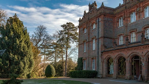
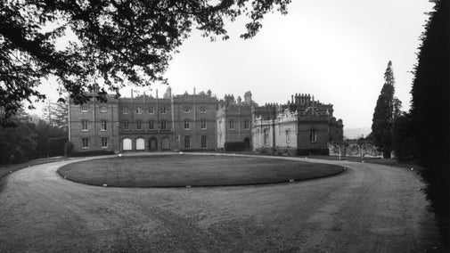
Red brick manor set in the Chiltern Hills. Former home to Benjamin Disraeli and a secret World War Two operation.
Formal Italianate-style gardens with Victorian parterre and classical statuary. Pleasure grounds, apple orchard and walled garden.
Open parkland with beech, oak and chestnut, soaring kites and resident cows. Parish church with Disraeli's grave. Rare chalk stream.
Over 600 acres of woodland and farmland set in the Chiltern Hills, with sweeping views over the surrounding countryside.
Natural play area created from giant fallen logs with walkways, a climbing rope and stepping stones. Suitable for under-10s. Play area closes at 4pm.
Stableyard café serving hot and cold drinks, sandwiches and sausage rolls and homemade cakes. Eat in or takeaway.
Stableyard shop filled with gifts, homeware, books, local produce and seasonal plants. Second-hand bookshop in the West Wing.
Three colour-coded waymarked walks can help you discover more of the estate, from a gentle one-mile stroll to a two-mile route, beginning from the visitor welcome kiosk.
With plenty of space to run, jump and play there's lots to keep children of all ages busy at Hughenden, including a 'Wild Play' area and activity trails in school holidays. Explore on your own, across acres of parkland and woodland, or keep a look out on our events page for seasonal activities, crafting or workshops.

Visit the house at Hughenden and discover its many stories, from being a famous prime minister’s home to a top-secret war base

Enjoy the symmetrical flower beds, clipped topiary and stonework of the formal garden design, or take a wander through the productive beds of the walled garden.

Explore the parkland on one of three colour-coded walks, with its carefully designed views, rare chalk stream and medieval church.

A joyful Christmas of twinkling charm, inspired by the joy of festive wishes to loved ones, it’s the perfect backdrop for making treasured Christmas memories with family and friends.

Celebrate the magic of Christmas with festive jazz! Join The Bluebird Belles trio for an unforgettable performances on Sunday 14 December, as they serenade you with holiday classics

Celebrate the magic of Christmas with festive jazz! Join local singer Lissie Allsopp for two unforgettable performances on Sunday 21 & 28 December, as she serenades you with holiday classics.

Sociable wellbeing walks around the Chiltern Hills in Buckinghamshire, suitable for all ages and abilities.

On this leisurely 1.2 mile walk, you'll loop around typical Chiltern farmland and woodland. Enjoy the peace and quiet of Woodcock Wood before heading back along 'Coffin Path'.

Explore beautiful woodland, open parkland, farmland and a rare chalk stream on this energetic 4-mile circular walk that runs close to the estate boundary.

Discover a short 2-mile return walk with moderate hill climbs that takes in the monument at Hughenden. Take in far-reaching views from the monument which is known to be is one of the best look-out points the area.

For varied views, go on this circular 5.6-mile walk around the Hughenden Manor estate, which reveals no fewer than 10 different views of the surrounding Chilterns countryside.

This 1.5-mile walk at Hughenden, Buckinghamshire, explores the evergreen woods inspired by Disraeli's visits to the Northern Bohemian forests.

Enjoy light snacks, hot meals and drinks in the café, then have a browse in the shop or pick up a bargain in the second-hand bookshop.

Follow the festive trail to follow the journey of a letter to Father Christmas — fun, games, and magical photo moments await!
Inspired by the magic of the first Christmas card and the golden age of letter writing, this year’s celebration brings together the elegance of the Victorian era and the heartwarming story of a 1940s wartime Christmas at Hughenden.
Little crafters, join us for a delightful crafting event to prepare for Christmas
Little crafters, join us for a delightful crafting event to prepare for Christmas.
Celebrate the magic of Christmas with festive jazz! Join local singer Lissie Allsopp for performances on Sunday 21 & 28 December, as she serenades you with holiday classics.
Join Michelle from Easely Does It for a peaceful, step-by-step acrylic painting session capturing the cozy magic of winter — a pair of mittened hands gently holding a heart-shaped snowball.
Toni from Easely Does It and Rebecca from Jack and Alice Crafts invite you to a truly magical creative retreat inspired by the ethereal beauty of the Northern Lights — blending painting, needle-felting, and a touch of winter sparkle.
Join Toni from Easely Does It for a peaceful, step-by-step acrylic painting session inspired by the ethereal glow of the Aurora Borealis.
Set in an unspoiled Chiltern valley with views of ancient woodlands and rolling hills, Hughenden offers a restful retreat from the pressures of everyday life, just as it did for Victorian Prime Minister, Benjamin Disraeli, and his wife Mary Anne. Outside, the surrounding views of the parkland invite you to explore the estate, following picturesque walking trails that take in the historic landscape of the Chiltern beech woods. In contrast to the exotic trees on the North Lawn, the Italianate formal gardens showcase annual beds full of the bold colours the Disraelis loved. Inside the manor, you can discover the top-secret Second World War operation codenamed ‘Hillside’.
Find out more about the history that surrounds this estate, from early Domesday records to becoming the home of Queen Victoria’s favourite Prime Minister, Benjamin Disraeli.

Find out about the life of Benjamin Disraeli, including his journey from charismatic young politician to twice-serving Prime Minister and his move to Hughenden Manor in Buckinghamshire.

The Air Ministry work at Hughenden was so secret it only came to light 60 years later. A chance encounter between a visitor and a house volunteer led to the beginning of further research. If you visit Hughenden Manor today, you can explore the original rooms where mapmakers worked. We have installed an immersive exhibition which gives an insight into the mapmakers’ work and personal lives.

Explore the objects and works of art we care for at Hughenden on the National Trust Collections website.

Find out how we’re doing our bit for bees, preserving heritage through gate and statue conservation, and uncovering the stories behind artifacts like the Spare Chair at Hughenden.

Would you like to volunteer at Hughenden? Come and join our friendly team, which helps to look after this magical country house in peaceful Buckinghamshire.


Join today and help protect nature, beauty and history – for everyone, for ever. Enjoy access to more than 500 places with National Trust membership.
By sharing your email address you’re agreeing to receive marketing emails from the National Trust and confirm you’re 18 years old or over. Please see our for more information on how we look after your personal data.