Woodland Explorer Walk
We’re finding that popular spots like Longshaw and the Eastern Moors are getting extremely busy, especially at weekends. We expect our car parks to fill up very quickly on weekends, bank holidays and school holidays, so we encourage people to plan ahead and check our social media channels for updates and visit at quieter times. This will help us keep our places safe and enjoyable for everyone. We ask that all visitors please park safely and considerately in designated spaces and not on roads or grass verges, as this can block access for farm tenants, local residents and emergency services. We also remind people that BBQs/campfires are not permitted and ask everyone to help us look after our beautiful Peak District countryside by taking their litter home with them.


Start:
Longshaw Visitor Centre, grid ref: SK264798
1
From the tea-room, cross the drive and turn left along the path by the fence. Go through a small gate. Turn right and go slightly downhill with Rhododendron bushes on your right and a ha-ha on the left to a small gate. Follow the path to the pond.
Designed landscape
Rhododendron bushes were planted as part of a formal walk from the Hunting Lodge down to Longshaw Pond in the 1800’s. A ha-ha is a combination of ditch and wall designed to keep deer out of the formal walk down to the pond. Longshaw Pond was created in 1827 as a fishing lake for the Duke and once had a boathouse and pier.

2
Follow the curve of the pond and then continue down the hill through Granby Wood to Granby Barn. Take a look inside and learn a little about the history and wildlife of the estate.
Higger Tor and Carl Wark
Look for Higger Tor and Carl Wark. Higger is the flat-topped, steep sided hill visible on the horizon, and Carl Wark the flat-topped feature below it. Higger Tor at 434m high is around 100m higher than Granby barn and has clear unobstructed views for miles over the surrounding countryside. Carl Wark has the remains of a bronze age fort from around 3,000 years ago

3
Follow the path down to the road, cross carefully to the small gate, go through and go slightly right down the path to the bridge over Burbage Brook. Cross the bridge and then look slightly right for the entrance to Hollowgate. Follow this old packhorse route with banks on either side covered in heather and gorse bushes.
Hollowgate packhorse track
Hollowgate was once a busy packhorse trail used to carry goods across the moors between Sheffield and Manchester and the west. Salt, lead and charcoal were some of the commodities transported.

4
When you reach the top of Hollowgate, don't go through the wooden gate but turn left up a sharp lincline. Owler Tor is off to your left. The wind and weather has transformed the relatively soft gritstone boulders and rocks into fantastic natural sculptures. A great location to stop for a picnic? Follow the path across Lawrence Field with the road on your right.
Lawrence Field
Lawrence field is a very special place on the estate with remains of a medieval field system and longhouses down towards the bottom of the field and a carpet of purple heather from mid-August. Sheep are kept on the field during spring and summer. Their grazing helps to preserve the moorland habitat. Surprise View is worth a little detour, off to the right at the end of Lawrence Field. From there you get a spectacular vista of the Hope Valley.

5
When you get to the end of Lawrence Field, with a 5 bar gate and stile directly in front of you, do not cross the stile but turn left and follow the path downhill keeping the fence line on your right. Over the fence is the top edge of Bolehill quarry which is popular with climbers. Around 500m down the path you will arrive at a fence with a small gate, go through this gate and continue on this path until it forks. Take the left fork and follow this towards the southern boundary wall of Lawrence Field. You will reach a gate on the right.
Bolehill Quarry
Bolehill Quarry was the source of millstone grit used to build the Derwent and Howden Dams between 1901 and 1914. Look out on your right, over the wall, for the remains of a fireplace and chimney, probably built and used by quarrymen as a headquarters. On your left, you will see the remains of medieval field boundaries.

6
Go through this gate and turn right onto the wide path descending the hill until you reach the end of this path and see an obvious path to your left.
Pied flycatchers
Look out for the nest boxes which are used by pied flycatchers in spring. Every spring the rangers keep flycatcher nestboxes closed up to stop other woodland birds from using them all. They start unplugging them in April, ready for the flycatchers to arrive from Africa.

7
Turn left and continue to descend until you reach the main Padley Gorge path, constructed out of gritsone blocks. Follow this up the valley until you reach a metal gate leading onto an open area strewn with boulders. Follow the path alongside Burbage Brook to a small wooden bridge. Cross the bridge and follow the path left and upwards to the gate below Granby Barn where you crossed the road early in the walk.
Padley Gorge
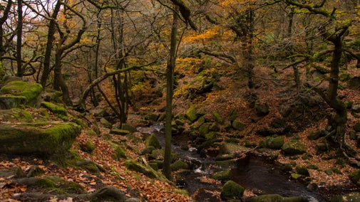
The ancient oak woodland of Padley Gorge have a rich ecology of mosses, ferns, fungi, flowers, trees and birds. The gnarled oaks are older than their size suggests because their roots are restricted by all the boulders in the soil. Look out for tiny woodland flowers in early spring, before leaves on the trees block out the light.

8
Cross the road carefully and retrace your steps past Granby Barn, the pond and back through the rhododendrons. This will lead you back to the tea-room where you started.
End:
Longshaw Visitor Centre, grid ref: SK264798