Skip to content
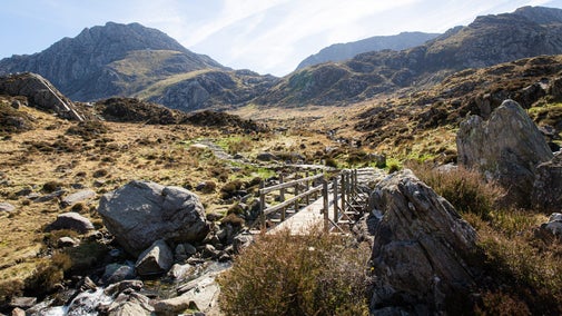
View of the landscape of Abergwesyn Common, Powys
View of the landscape of Abergwesyn Common, Powys | © National Trust Images/Paul Harris
Wales

Llanwrthwl horseshoe walk

This trail begins and ends in the quiet village of Llanwrthwl and takes in panoramic views across the uplands of Brecon and Radnorshire, including the 'roof of Wales', the Cambrian mountains.

Blanket bog and open moorland

This walk is only suitable for experienced hill walkers due to the lack of clear paths. Proper walking footwear is recommended.

Total steps: 9

Total steps: 9

Start point

St Gwrthwl's Church, Llanwrthwl, Llandrindod Wells, LD1 6NT. Grid ref: SN975637

Step 1

Starting the walk from the church in Llanwrthwl, follow the minor road that runs down the left hand side of the churchyard. This section of the route follows the line of the Wye Valley Walk recreational trail. Continue along this road for approximately 2 miles (3.5km) until you reach a fork in the road.

Step 2

Take the right-hand track, still on the Wye Valley Walk, and pass through the wooden field gate. You're now onto National Trust land, as the sign for Trembyd mountain indicates. Follow the stone track upwards for approximately 1 mile (1.5km) at which point you'll see the grassed bridleway heading up in front as the stone track turns left and downwards. Take the bridleway up until you reach a dry-stone wall and field gate at the top.

Step 3

Turn right in front of the gate and follow the fence line upwards, heading for the summit of Trembyd. At the top of Trembyd hill you will find a pile of stones that was once a burial cairn. Enjoy the views from the hilltop while you catch your breath from the climb up. From here, head towards Drum Ddu to the south-west.

Step 4

Head across the saddle between the two hilltops. If you stay to the right of the wetland area you will keep your feet drier and pass by two further cairns. Once across the saddle, make your path diagonally left up the hillside, until you reach the top. From here you can walk along the flatter grassed path to the cairn at Drum Ddu.

Step 5

From the Drum Ddu cairn, follow the path along the ridge for approximately 400 yards (400m), until you pick up the track heading off downwards to the right towards Rhos Saith Maen. This section of the route may not always be clear to see, so pick your best way down the hillside. As you walk down into valley, look up and ahead for the track heading up to the left on the hill opposite, up towards the summit of Y Gamriw. Known as Rhiw Saeson, this is the route to head towards as you cross the valley floor.

Step 6

Once you've crossed over the track that runs through Rhos Saith-maen, follow the route to the base of Y Gamriw. This area can be wet underfoot for much of the year, so pick your route carefully. Follow the track that leads upwards to the ruins of a building at the top.

Step 7

From here, turn right and take the route to the summit which goes from the left-hand side of the ruins. The summit cairn is reached before you arrive at the trig point, which marks the highest point of this walk at 1,969ft (600m).

Step 8

From the trig point on Y Gamriw, follow the ridge line north-eastwards back towards Llanwrthwl. You'll pass several ancient cairns on your way, revealing glimpses of the history that this area contains.

Step 9

As you reach the end of the ridge you'll need to pick out the zig-zag path that goes down to, and eventually through the woodland above Dol-lago farm. At the farm, follow the blue-arrowed bridleway signs that take you between the farm buildings and down the farm track that leads to the road. At the road, turn left and continue to the T-junction. Turn right here, and follow the road back through the village to the church.

End point

St Gwrthwl's Church, Llanwrthwl, Llandrindod Wells, LD1 6NT. Grid ref: SN975637

Trail map

Map showing the Llanwrthwl Horseshoe walk at Abergwesyn Common in Powys, Wales
Llanwrthwl Horseshoe walk map, Abergwesyn Common | © Crown copyright and database rights 2022 Ordnance Survey

You made it

Share your experience

More near here

A view of Corn Du mountainside in the Brecon Beacons showing the steep slope and footpath erosion.
Trail
Trail

Pen y Fan and Corn Du circular walk 

Follow this strenuous, circular mountain walk on well-made footpaths to the summit of Pen y Fan and Corn Du in the Brecon Beacons.

Activities
Walking
DistanceMiles: 4 (km: 6.4)
Visitor taking picture of waterfall with his phone while standing on small cliff above pool of water at Henrhyd Falls in the Brecon Beacons, Wales
Trail
Trail

Henrhyd Falls and Nant Llech walk 

Explore the Graig Llech Gorge and tranquil Nant Llech Valley on this adventurous Brecon Beacons walk to see the highest waterfall in South Wales.

Activities
Walking
DistanceMiles: 3.5 (km: 5.6)

Our partners

Cotswold Outdoor

We’ve partnered with Cotswold Outdoor to help everyone make the most of their time outdoors in the places we care for.

Visit website 

You might also be interested in

Two women walking on a path through woodland on Southwood Estate, Pembrokeshire in Wales

Walking in Wales 

Explore wide open landscapes, gentler coastal strolls or energetic hikes for something a little more challenging. We've rounded up some of the best places to walk in Wales.

View from Pen y Fan to Corn Du in the Brecon Beacons National Park, South Wales.
Article
Article

Exploring the countryside at Abergwesyn Commons 

Discover a place of unspoilt and dramatic landscapes, where steep-sided valleys give way to spectacular open commons with far-reaching views across to the Brecon Beacons.

A person walking along a footpath in a grassy landscape on Tennyson Down on the Isle of Wight
Article
Article

Top tips for hill and mountain walking 

Learn about the essential clothing and equipment to take with you, keeping your energy levels up, staying safe and leaving the environment as you found it.

An aerial view of an adult and baby walking a dog along a path at Baggy Point, Devon
Article
Article

Staying safe at National Trust places 

The special places in National Trust care sometimes come with a few risks for visitors, be it coastline or countryside. Find out how to keep safe throughout your visits.
Walkers climbing rocks against a bright blue sky with the mountains in the distance at Sugarloaf, Monmouthshire

Walking 

Explore some of the finest landscapes in our care on coastal paths, accessible trails, woodland walks and everything in between. Find the best places to walk near you.

A group of people in a hiking group are being guided on a hike by rangers at Marsden Moor, West Yorkshire
Article
Article

Cotswold Outdoor: our exclusive walking partner 

Find out more about the National Trust’s ongoing partnership with Cotswold Outdoor as our exclusive walking partner.

A visitor carrying a backpack and walking along a footpath at Divis and the Black Mountain with stone walls either side, the countryside visible in the background.
Article
Article

Follow the Countryside Code 

Help to look after National Trust places by observing a few simple guidelines during your visit and following the Countryside Code.

A walker standing on the Pembrokeshire coast looking out at the sea.
Article
Article

Coastal walks in Wales 

Discover the best walks along the Welsh coast, taking in picturesque peninsulas, rugged headlands, quaint hamlets, prehistoric monuments and outstanding wildlife.