Skip to content
Downs Banks' character landscape
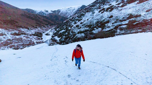
This walk shows off all of Downs Banks' character | © Paul Roberts
Shropshire & Staffordshire

Downs Banks Edges walk

Taking you over hills and through secret valleys, this walk contrasts the wild places on your left with green farmland on the right.

Total steps: 11

Total steps: 11

Start point

Downs Banks main car park, grid ref: SJ900365

Step 1

Start at the main car park. A grassy area is just uphill of the car park. Go into the grassy area and carry on up the gentle rise as the path leads into the trees. The lane will be visible on your right. Carry on until you reach a gate on your right and a National Trust sign. Then turn left up a narrow valley.

Step 2

Follow the path along the valley and climb a short line of wooden steps. Continue through a wooden gate. Leave the woods behind as you walk onto the grassy hill top.

Step 3

Keep the fence to your right until you see a stone pillar on the hilltop to your left. Follow the broad path to this pillar.

Step 4

Turn northwards (follow the line on the viewpoint pointing towards Meir Church). At the edge of the grassland a narrow path heads steeply downhill. Taking care on the steepest sections, follow this path to a broader track at the foot of the slope.

Step 5

Turn right along the broad track and towards a fence. At the fence turn left and follow the path uphill with the fence to your right.

Step 6

The path follows the fence uphill to a group of pine trees. Here it curves to the left and continues close to the fence into woodland. When you reach a large wooden gate, pass through and look for a smaller gate on the left.

Step 7

Walk through the small gate and into a field. Follow the path across the field and over a bridge. Another gate is in front of you. Go through the gate and turn right.

Step 8

Walk along the firm, broad path and up the bank (don't worry, it's not as steep as it looks). At the top of the hill turn left and keep the fence to your right.

Step 9

The path is quite level and straight for some distance. It only dips a little and begins to descend after passing through a small gate. Follow this path until you reach the stream.

Step 10

At the brook, turn right and follow it downstream. Walk through the gate and turn left, crossing the stream for the final time over a footbridge. Walk up the lane until you reach the drive to the main car park a short while later.

Step 11

Turn in to the entrance drive and you will see the car park on your left. Congratulations, you have conquered the Downs Banks Edges.

End point

Main car park, grid ref: SJ900365

Trail map

Map route for Downs Banks Edges walk
Map route for Downs Banks Edges walk | © Crown copyright and database rights 2013 Ordnance Survey

You made it

Share your experience

More near here

Dog on a walk
Trail
Trail

Downs Banks dog walk 

This little wilderness of woodlands and heath in the heart of the West Midlands is a fantastic place to explore with your dog.

Activities
Walking
DistanceMiles: 2 (km: 3.2)
Ironbridge Gorge, world heritage site, shropshire.
Trail
Trail

Benthall Hall Ironbridge walk 

This high energy walk takes you down into Ironbridge, the 'Birthplace of the Industrial Revolution'. Explore the independent shops and cafes in the town before returning back to Benthall.

Activities
Walking
DistanceMiles: 3.4 (km: 5.44)
Benthall parkland autumn trees Shropshire
Trail
Trail

Benthall parkland and meadow walk 

Take a stroll around the parkland and meadows, to discover a variety of grassland flora and fauna.

Activities
Walking
DistanceMiles: 1.5 (km: 2.4)

Get in touch

Washdale Lane, Oulton Heath, Near Stone, Staffordshire

Our partners

Cotswold Outdoor

We’ve partnered with Cotswold Outdoor to help everyone make the most of their time outdoors in the places we care for.

Visit website 

You might also be interested in

Visitors enjoying the autumn sunshine at Carding Mill Valley and the Shropshire Hills, Shropshire. The site covers 2000 hectares of heather-covered hills featuring iconic views of the Shropshire Hills.

Walking in Shropshire and Staffordshire 

Find out about the best walking routes around Shropshire and Staffordshire, including gardens, parkland and estates, ideal for family walks.
Visitor crossing water via stepping stones with their dog on an autumnal walk at Wallington

Walking 

Explore some of the finest landscapes in our care on coastal paths, accessible trails, woodland walks and everything in between. Find the best places to walk near you.

Downs Banks Brook meandering through woodland at Downs Banks, Staffordshire
Article
Article

Volunteer at Downs Banks 

From repairing fences to helping protect vital wildlife habitats, there’s a lot to get involved in while volunteering with the Staffordshire conservation volunteers at Downs Banks.

A visitor carrying a backpack and walking along a footpath at Divis and the Black Mountain with stone walls either side, the countryside visible in the background.
Article
Article

Follow the Countryside Code 

Help to look after National Trust places by observing a few simple guidelines during your visit and following the Countryside Code.

An aerial view of an adult and baby walking a dog along a path at Baggy Point, Devon
Article
Article

Staying safe at National Trust places 

The special places in National Trust care sometimes come with a few risks for visitors, be it coastline or countryside. Find out how to keep safe throughout your visits.

A group of people in a hiking group are being guided on a hike by rangers at Marsden Moor, West Yorkshire
Article
Article

Cotswold Outdoor: our exclusive walking partner 

Find out more about the National Trust’s ongoing partnership with Cotswold Outdoor as our exclusive walking partner.