Skip to content
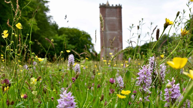
A wildflower meadow with lots of purple and yellow flowers surrounding King Alfred's Tower at Stourhead
King Alfred's Tower provides an imperious backdrop to this wildflower meadow | © National Trust Images/Tamsin Holmes
Wiltshire

Alfred's Tower walk at Stourhead

This is a circular walk of historic interest which takes you up through beautiful woodlands to Alfred’s Tower and returns through Park Hill Camp Iron Age hillfort and Turner’s Paddock. Alfred’s Tower is a 160ft (49m) high folly, designed by Henry Flitcroft for Henry Hoare II in 1772. It is believed to mark the site where King Alfred the Great rallied his troops in 878. The tower commemorates the accession of George III to the throne in 1760 and the end of the Seven Years War.

Alfred’s Tower car park start point

If you're starting your walk from Alfred’s Tower car park, please head to the tower and start from point 4.

Total steps: 7

Total steps: 7

Start point

Stourhead visitor reception, near Mere, Wiltshire BA12 6QD. Grid ref: ST778340. You can start the walk from Alfred’s Tower car park (grid ref grid reference ST749354): please head to the tower and start from point 4.

Step 1

From the main car park, go through visitor reception. Take the zig-zag path down to the Spread Eagle Inn. Walk through the car park and courtyard. Watching out for traffic, turn left here and walk down the road, passing St Peter’s Church on your left. Continue along the road until just beyond the Rock Arch, where you turn right.

Step 2

Continue walking with Turner’s Paddock lake and the waterwheel on your left. Keep following the track beside the cattle grid, past Beech Cottage on your right and over a stile. Go a little further on the main track and where it forks, take the right-hand track and go through the gate. Follow the track along the top of the field. The ruins of Tucking Mill and cottages are on your left.

Step 3

Go over the stile at the gate and through the mixed conifer woods, keeping on the main track and going straight ahead at any junctions. After a steep ascent of around one mile, the track will come out on to part of the 18th-century Terrace Ride. Turn left here and walk for around ½ mile until you reach Alfred’s Tower.

Step 4

On leaving the Tower, retrace your steps along the Terrace ride (following the blue waymarkers) to where the woodland area on your right ends. Turn right, down the forestry track on the edge of the woodland, keeping the field on your left.

Step 5

Keep following the main track as it bears 90 degrees to the right. Walk along the Broad Ride through the woodland. After around ½ mile (800m) you will reach Park Hill Camp Iron Age hillfort. Go straight through the hillfort. (If sheep are grazing, dog walkers will need to follow a clearly marked small diversion.) After exiting the hillfort by the information panel, keep on the main track for another ½ mile (800m) then follow it round to the right. Descend the hill and go through the gate into Turner’s Paddock.

Step 6

Continue along the track, bearing left where you rejoin the main track. Go through the gate beside the cattle grid, passing Turner’s Paddock lake and the waterwheel on your right. As you reach the road, turn left, going under the Rock Arch. Being mindful of traffic, continue along the road passing St Peter’s Church on your right. At the Spread Eagle Inn, turn right and go through the courtyard and car park and follow the footpath that zig-zags up the hill to visitor reception and the car park.

Step 7

If you are starting your walk from Alfred’s Tower car park, please head to the tower and start from point 4.

End point

Stourhead visitor reception, near Mere, Wiltshire BA12 6QD. Grid ref: ST778340.

Trail map

Stourhead King Alfred's walk map
Stourhead King Alfred's walk map | © Crown copyright and database rights 2013 Ordnance Survey

You made it

Share your experience

More near here

Aerial view of earthworks in the landscape at Whitesheet Hill, Wiltshire
Trail
Trail

Stourhead Whitesheet Hill walk 

Look out for an array of wildflowers & wildlife and take in the wide views of Stourhead estate on this challenging walk up Whitesheet Hill, a site of great archaeological interest.

Activities
Walking
DistanceMiles: 6 (km: 9.6)
Families explore by the lake at Stourhead, which is surrounded by trees in autumn yellows and oranges
Trail
Trail

Stourhead Park Hill Camp walk 

This picturesque circular walk takes in Park Hill Camp Iron Age hillfort and the Six Wells Valley, with plenty of birdlife to look out for and carpets of bluebells in spring.

Activities
Walking
DistanceMiles: 3 (km: 4.8)
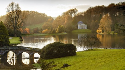
The domed, white Temple of Apollo surrounded by trees overlooking the lake at Stourhead
Trail
Trail

Bonham Wood walk at Stourhead 

This gentle walk takes you behind the Temple of Apollo through the picturesque Bonham Wood, and returns along a WWII airfield. A springtime hotspot also for daffodils and bluebells.

Activities
Walking
DistanceMiles: 2.5 (km: 4)

Get in touch

near Mere, Wiltshire, BA12 6QD

Our partners

Cotswold Outdoor

We’ve partnered with Cotswold Outdoor to help everyone make the most of their time outdoors in the places we care for.

Visit website 

You might also be interested in

Light on a tulip tree on an island in the lake at Stourhead, Wiltshire
Place
Place

Stourhead 

Palladian house and world-famous landscape garden

near Mere, Wiltshire

Fully open today
Visitors and their dog walking with far reaching views all around at Whitesheet Hill near Stourhead in Wiltshire
Article
Article

Explore the estate at Stourhead 

Explore the wider countryside around the Stourhead estate. Discover an Iron Age hillfort, Alfred’s Tower and ancient woodland. Then rest a while and listen to the wide variety of birds and creatures that call this estate home.

The view of the Pantheon building from across the still lake, with autumn trees and blue sky reflected in the water
Article
Article

Things to see in the garden at Stourhead 

Stourhead is home to one of the world's most famous gardens, with myriad temples, grottos, trees and water features to explore. Read more about what you'll see during your visit.
A small dog on a lead on the grass
Article
Article

Visiting Stourhead with your dog 

Find out about visiting the Stourhead estate with your dog, from where you can and can't take them, to the facilities available to dog owners. Stourhead is a two pawprint rated place.

A family group wearing winter coats sit at a wooden outside table with takeaway hot drinks cups
Article
Article

Eating and shopping at Stourhead 

Discover the best places to eat, drink, and buy gifts and souvenirs during your visit to Stourhead.

A group of people in a hiking group are being guided on a hike by rangers at Marsden Moor, West Yorkshire
Article
Article

Cotswold Outdoor: our exclusive walking partner 

Find out more about the National Trust’s ongoing partnership with Cotswold Outdoor as our exclusive walking partner.

An aerial view of an adult and baby walking a dog along a path at Baggy Point, Devon
Article
Article

Staying safe at National Trust places 

The special places in National Trust care sometimes come with a few risks for visitors, be it coastline or countryside. Find out how to keep safe throughout your visits.

A visitor carrying a backpack and walking along a footpath at Divis and the Black Mountain with stone walls either side, the countryside visible in the background.
Article
Article

Follow the Countryside Code 

Help to look after National Trust places by observing a few simple guidelines during your visit and following the Countryside Code.