Wimpole archaeology walk, Wimpole Estate, Cambridgeshire
This walk is about 1 mile and is mainly on flat ground; it takes about an hour to complete, and most of the land you will be walking on is now scheduled as an Ancient Monument.
An ideal walk for families.


Start:
Stable block, grid ref: TL336509
1
From the entrance to the stables, turn left and cross the estate road heading through the kissing gate into the field beyond.
Kendall Stables
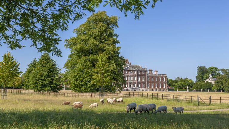
The stable block was designed by H. E. Kendall (1776-1875) and constructed in 1852, replacing 17th century Stables that were nearer the Hall.

2
Bearing slightly to your right, continuing for approximately 300yd (275m) until you reach a fish pond, surrounded by a fence and a copse of trees.
18th-century fish pond
The second Earl of Radnor had a string of six ponds dug here at the end of the 17th century, with water running from one to the other. Fish at this time were always a luxury food in areas far from the sea. Some of these ponds were filled in during the 1720s to allow for Bridgeman’s vista towards Whaddon steeple, and by 1815 only one remained — and that is the one you see today.
3
Continue on and immediately south of the pond you will very shortly reach the site of Thresham End.
Thresham End
Immediately south of this pond is the site of the settlement of Thresham End. This is documented as existing as early as the 15th century and in 1638 it formed part of the village of Old Wimpole. Hare’s map shows it to have consisted of four houses along Wimpole Way. Thresham End was demolished in the late 17th century when Chicheley and John Cutler developed the park; and very little is visible today except for one well-formed platform which is possibly the site of a house. Some of the lumps and bumps in this area are old house sites; the shallow hollow between the ponds is the old village street.

4
Beyond the site of Thresham End bear right and head towards the right hand side of a fenced area surrounded by trees. This is My Lady’s Pond.
My Lady's pond
This fish-pond was probably dug in the 1720s by Edward Harley to replace those which were lost during Bridgeman’s improvements.

5
Bearing slightly to your right continue to the edge of the field towards the five-bar gate. Get a good view of the Avenue in front of you.
Four Acre Covert
On the left as you approach the bottom of the field is a small area of woodland. This is Four Acre Covert which was planted c1840 mainly with oak, probably for the rearing of young pheasants or as covert for hunting. Many such copses in the park which began life as purely functional parts of the landscape, have now evolved into locally important habitats for wildlife. Fallow deer and foxes are often seen here.

6
Now without going through, turn right at the five-bar gate in front of you and continue across the Avenue following the fence, going through a small kissing gate to the right of the small copse ahead.
Southern end of the park
The large ditch on your left was the southern end of the park as extended by Chicheley in the 1650s. At this time the boundary was marked by the medieval Rushbrooke Way. leading from Orwell towards Bennall End. When the 2nd Earl of Radnor extended the gardens towards the south, the hollow-way was probably dug deeper to make a ditch to keep out the deer. As you go through the gate you can see on your right two Lombardy poplars. These were planted in the 1880’s near two cricket pavilions, now demolished. On your right the broad bank down the middle of the Avenue is the original South Avenue; the flattened area is the cricket pitch.
7
Now bear to the right and head for the corner of the small copse ahead of you.
Small copse
Within the copse there are two further fish ponds, probably dug in the 1720's and like the other ponds they get water from drainage pipes laid all over the park in the 18th century. At the time the owners wanted to improve the grassland to make better grazing. The beeches clustered on the west side date from the 1780's.
8
Between the area of recent replanting in the copse and the estate road look to your right at the uneven ground
Bennall End
This is the site of Bennall End, another mediaeval settlement. Shards of pottery of the 13th century have been unearthed here suggesting that the site was inhabited at least by then. At the time of Hare's map of 1638 the settlement consisted of ten houses, and the banks and ditches of the property plots are clearly visible. Bennall End appears to have been a later addition to the scattered village of Wimpole which had probably become over-populated. This development reflects the typical population growth of 12th and 13th-century England. . Bennall End was again cleared when the park was extended under Chicheley in the late 17th century. The village population would have moved to the new outlying farms.
9
Having passed the copse, continue until reaching the Estate road stop by the kissing gate and look to your left down the drive to the site of the American military hospital.
American Military Hospital
On the flat ground looking towards the Arrington gates, was the site of an American military hospital built during the Second World War. After the war it was used for a short time as a teacher training college before it was demolished in the 1950s.
10
At this point, turn right and walk along the estate road towards the house.
Old Pasture
On the rising ground before you is one of the finest areas of old pasture in the park. Walk up the hill and you can see native grasses e.g. yellow oat grass, meadow barley and crested dogstail, plus herbs such as lady’s bedstraw. Invertebrates, such as grasshoppers are common.
11
Continuing along the estate road, stop by the large oak tree on the right hand side.
Large oak
If you look high up into the tree you can see some thick chains around the middle boughs. These chains were commonly used for supporting big limbs of older trees.
12
Continue until reaching a cattle-grid on the lawn in front of the Hall, and the remains of an ornamental water garden. After examining these remains continue along the road in front of the hall to the stables where the walk ends.
Old Water garden
Beyond the cattle grid on the lawn in front of the hall, is a back-filled square moat-like feature crossing the path. This is the remains of an ornamental water garden developed by the 2nd Earl of Radnor, originally surrounded by elms. Kip’s engraving of 1707 shows that small trees in tubs used to stand in the central plot, probably oranges in the west wing of the house (now demolished). This garden appears to have been demolished during the ‘naturalising’ period of ‘Capability’ Brown and William Eames. The big lime tree in one corner is one of the older trees in the park, and is probably 350 years old.
End:
Stable block, grid ref: TL336509