Botallack and Kenidjack coastal walk
Cornwall
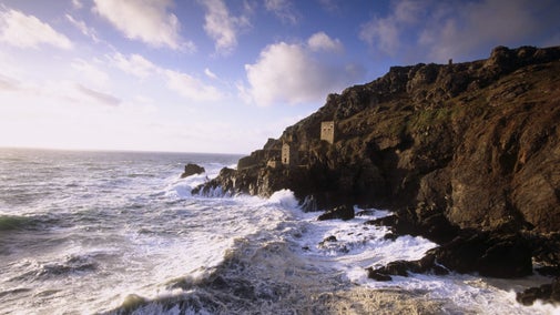
Explore the industrial heritage of Cornwall's Tin Coast on a stunning walk across clifftop heathland. Starting with views of the famous Crowns Engine Houses, this circular route shows why the St Just area is so special. Listen out for the distinctive ‘cheow’ of passing choughs or catch a glimpse of basking sharks.
Near to
BotallackStart point
Botallack National Trust car park, grid ref: SW365332Trail information
Watch your step
This walk explores exposed coast paths and industrial heritage. Please keep well back from cliff edges with steep drops, and be aware that there are old mine shafts.
Botallack
On the wild Tin Coast, the famed Crowns engine houses cling to the foot of the cliffs. Part of the Cornish Mining World Heritage Site and Poldark filming location.

Botallack mining walk
Discover Cornish mining heritage on this beautiful one mile walk around Botallack.

Get in touch
Our partners

We’ve partnered with Cotswold Outdoor to help everyone make the most of their time outdoors in the places we care for.
You might also be interested in
Walking
Explore some of the finest landscapes in our care on coastal paths, accessible trails, woodland walks and everything in between. Find the best places to walk near you.

Top coastal walks
Explore some of the UK's most famous natural landmarks on a coastal walk. With a variety of walking trails offering clifftop views, golden sands and local wildlife, there's a walk for everyone.

Cotswold Outdoor: our exclusive walking partner
Learn about the National Trust’s ongoing partnership with Cotswold Outdoor. Find out how they help us care for precious places and the exclusive discount available for National Trust supporters.

Staying safe at National Trust places
The special places in National Trust care sometimes come with a few risks for visitors, be it coastline or countryside. Find out how to keep safe throughout your visits.

Follow the Countryside Code
Help to look after National Trust places by observing a few simple guidelines during your visit and following the Countryside Code.

Explore Botallack
Explore the wild Tin Coast, part of the Cornish Mining World Heritage Site and see the iconic engine houses clinging to the cliff face.

Top tips for coastal walks
Get safety tips for walking by the coast, including the essential clothing and equipment to take with you and what to do before you set out.

Walking in Cornwall
From strolls that reward you with stunning views of the South West coast to gentle inland meanders, these are some of the best walks in Cornwall.


