Become a member
Join today and help protect nature, beauty and history – for everyone, for ever. Enjoy access to more than 500 places with National Trust membership.
Remote mountains steeped in history, deep wooded valleys and spectacular estuaries.
Dolmelynllyn car park, Ganllwyd, Dolgellau, Gwynedd, LL40 2TF

| M | T | W | T | F | S | S |
|---|---|---|---|---|---|---|
Open
Closed
| Asset | Opening time |
|---|---|
| Countryside | Dawn - Dusk |
Cafés at Barmouth town centre.
Dolmelynllyn - National Trust car park Cregennan - National Trust car park Dinas Oleu - public car park
Dogs allowed on lead. Please be mindful of livestock.
Pub at Barmouth town centre.
Restuarant at Barmouth town centre.
Countryside locations with uneven, steep, rocky and boggy terrain in places, may also include narrow gates and styles.
Cregennan - footpath around lake Dinas Oleu - footpath from Barmouth town centre. Steep parts to path up to Dinas Oleu
Dolmelynllyn - uneven and steep path in places. Dinas Oleu - footpath from Barmouth town centre. Steep parts to path up to Dinas Oleu.
Follow in the footsteps of legends around Eryri (Snowdonia) with your dog. Whether you want a gentle stroll or a mountainous walk, here's a selection of destinations to tire out all four legs (and yours).

Remote unspoilt mountains steeped in history, deep wooded valleys and spectacular estuaries.
Includes Rheaedr Ddu waterfall, a Celtic rainforest rich in lichens and bryophytes. Cefn Coch Gold mines and parkland.
A heather-clad hillside overlooking Barmouth, the very first parcel of land to be donated to the Trust in 1895.
Two lakes surrounded by ffridd and nationally important geolocial sites as well as two sheep and cattle farms.
Walk through Allt-y-môr, overlooking Harlech beach, for a viewpoint that's not to be missed with panoramic views across Cardigan Bay.
Explore the remote rugged landscapes of south (Eryri) Snowdonia. Ancient oak woodland at Dolmelynllyn and the volcanic rocks at Cregennan provide natural habitats for a wide variety of wildlife. Look closely beneath your feet to seek glacial fossils and rare lichens across the heathland.

See the cascading Rhaeadr Ddu Falls and impressive remains of Cefn Coch gold mine on the Dolmelynllyn Estate walk in South Snowdonia.

Follow this circular walk from Ganllwyd, through oak woods and along the River Gamlan, taking you to the dramatic Rhaeadr Ddu waterfalls.

Wind through the old town up to the gorse-covered Dinas Oleu, donated by Victorian Fanny Talbot to the people of Barmouth in 1895: the first area of land given to the National Trust.

Enjoy a relaxing, wheelchair-friendly walk around the restored lake at Dolmelynllyn, which is fantastic for wildlife-watching.


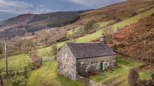
An 18th-century stone cottage on a working hill farm, with a wood-burning stove and valley views.

A perfect country cottage full of original beams and an inglenook fireplace, set in green farmland.

Get away from it all in this traditional Welsh countryside cottage in the wilds of Eryri (Snowdonia).

The lodge is near to the entrance of Dolmelynllyn Hall, a pretty cottage which is the perfect bolthole for exploring south Eryri (Snowdonia).

Originally built as an observatory, you can watch stars and wildlife from this cosy cottage.

An impressive Medieval Hall house in its own private walled garden, on working farmland.
Sorry, there are no upcoming events at this place
Bordered by the beautiful Dwyryd and Dyfi estuaries, the mountains of south Snowdonia include some of Wales' most fascinating National Trust places It is here that the roots of the Trust took hold, with the acquisition in 1895 of Dinas Oleu. Separated by the dramatic Mawddach estuary, the mountain ranges of Cader Idris and the Rhinogydd dominate the scenery and the area's coastline includes some of the most ecologically important sand dunes in the British Isles. The area is a stronghold of the Welsh language and culture and is extremely rich in prehistoric and medieval archaeology.
Dinas Oleu became our first piece of land that we would protect for everyone, for ever. Discover why Mrs Fanny Talbot donated this land for protection.

Find out how cattle are helping bring woodlands to life through conservation grazing that creates a diverse habitat and increases wildlife.


Join today and help protect nature, beauty and history – for everyone, for ever. Enjoy access to more than 500 places with National Trust membership.
By sharing your email address you’re agreeing to receive marketing emails from the National Trust and confirm you’re 18 years old or over. Please see our for more information on how we look after your personal data.