Skip to content
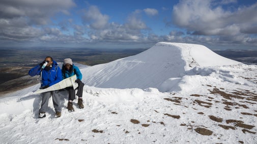
View from Mynydd Sygun, Snowdonia
View from Mynydd Sygun, Snowdonia | © National Trust Images
Wales

Craflwyn Ranger Run

This trail run starts and finishes at Craflwyn, but allows you to explore much of the wider Nant Gwynant valley, the village of Beddgelert as well as the lower slope of Wales's highest peak, Yr Wyddfa (Snowdon) and Mynydd Sygun, where you can see old copper mines.

Challenging run

This route is designed for experienced fell runners. Only parts of this route is waymarked. Please ensure you have a map and compass with you, check the weather before setting off and be fully prepared for a day out in the mountains.

Total steps: 9

Total steps: 9

Start point

National Trust Craflwyn car park, LL55 4NG. Grid reference SH599489

Step 1

From the car park at Craflwyn take the footpath leading up through the woodland. At the fork in the path, follow the black arrow waymark to the right. Continue past the dragon bench and then up some steps with a small waterfall to your left.

Small waterfall at Craflwyn, Snowdonia
Small waterfall at Craflwyn, Snowdonia | © National Trust Images

Step 2

At the top of the steps follow the path to the right, through some birch trees and into a clearing. Continue ahead following the black arrows and ignoring two paths that lead to the right. Stop off to admire the view from the Giant's Chair on your right, before continuing to the left and climbing up some steps (ignore the stile on your right). Follow the path as it weaves up, cross a small stile over a fence and head up towards the ffridd.

The Giant's chair at Craflwyn, overlooking Dinas Emrys and Mynydd Sygun in Snowdonia
The Giant's Chair at Craflwyn, Snowdonia | © National Trust Images

Step 3

Head east towards Bylchau Terfyn. Cross a stile at the wall and continue following the black waymarks. When you reach the bridge near an old ruin, turn left onto a track and continue upwards. Turn left again at the next ruin. Continue on the path until you reach another stile over a wall. Follow the waymarks down towards the Watkin Path. On a clear day you'll be able to see Llyn Gwynant and Moel Siabod in the distance.

Step 4

When you reach a track (the Watkin Path), turn right and descend the slope of Snowdon. Please note that the black waymarks end here.

Step 5

At the bottom of the track, turn right onto a lane and then right again at the main road. After passing Caffi Gwynant take the next left turning, crossing the river Glaslyn. Followed by the first right, signposted Llyndy Isaf Farm. Follow the track past the farm and run alongside Llyn Dinas – you will pass through several gates on the way.

Step 6

At the end of the lake, turn left up a stone-pitched footpath that zig-zags up the hill. At the top continue for half a mile (ignore the first path on the right). At the fork, bear right.

Step 7

From Bwlch y Sygun take the left path (heading south) then bear right, down Cwm Bychan. At the bottom continue past the car park and through the woods until you come to the river.

A view of Cwm Bychan ropeway, a relic of the copper mining industry in Snowdonia, Beddgelert, Wales.
Visit Cwm Bychan ropeway, a relic of the copper mining industry | © National Trust Images/Graham Eaton

Step 8

Turn right at the river and follow the Glaslyn upstream. Take care on the uneven, rocky terrain and when crossing the railway. Continue straight at the rail crossing. Pass a footbridge on your left and follow the river upstream, before crossing a street and going through a gate. After passing through Aberglaslyn Gorge, follow the path along the river with the lower slopes of Mynydd Sygun on your right.

Step 9

At the next gate, turn right onto a narrow lane and follow this to Sygun Copper Mine. Here, turn left onto the busy main road and left again until you reach Craflwyn car park on the right.

End point

National Trust Craflwyn car park, LL55 4NG. Grid reference SH599489

Trail map

Running route exploring Nant Gwynant valley starts and ends at Craflwyn, Snowdonia
Map route for Craflwyn Ranger Run, Snowdonia | © Crown copyright and database rights 2013 Ordnance Survey

You made it

Share your experience

More near here

View of Nant Gwynant from Dinas Emrys, Beddgelert, North Wales
Trail
Trail

The legendary trail of Dinas Emrys 

Enjoy a pleasant walk past waterfalls and through beautiful oak woodland to reach this summit of this legendary hill, where Merlin once trod and where a dragon still sleeps.

Activities
Walking
DistanceMiles: 2.2 (km: 3.52)
Path along the river in Beddgelert, Snowdonia, Wales
Trail
Trail

Gelert's grave walk 

This walk leads you from the village centre, along River Glaslyn's banks to Gelert's grave site. You'll also discover the legend of Gelert & Prince Llywelyn which gave the village its name.

Activities
Walking
DistanceMiles: 1 (km: 1.6)
Walkers navigating a narrow path beside the Glaslyn river, Craflwyn and Beddgelert, Wales.
Trail
Trail

Aberglaslyn, Llyn Dinas and Cwm Bychan walk 

Explore Aberglaslyn gorge, the waters of Llyn Dinas, the beautiful village of Beddgelert and Cwm Bychan copper mine on this challenging route in Eryri (Snowdonia).

Activities
Walking
DistanceMiles: 5.7 (km: 9.12)
View of lake stretching into distance with rocky hill to on side
Trail
Trail

Craflwyn, Hafod y Llan and Llyn Dinas walk 

Explore the wild and lonely heath and ffridd beneath Yr Aran, the lower slope of Wales' highest peak, Yr Wyddfa (Snowdon), the amazing waterfalls of Afon Cwm Llan and the stunning Llyn Dinas lake on this circular walk.

Activities
Walking
DistanceMiles: 6.5 (km: 10.4)

Get in touch

near Beddgelert, Gwynedd, LL55 4NG

Our partners

Cotswold Outdoor

We’ve partnered with Cotswold Outdoor to help everyone make the most of their time outdoors in the places we care for.

Visit website 

You might also be interested in

View from Mynydd Sygun, Snowdonia

Walking in Wales 

Explore wide open landscapes, gentler coastal strolls or energetic hikes for something a little more challenging. We've rounded up some of the best places to walk in Wales.
Heather and rock outcrops on Hafod Y Llan farm, with Yr Aran summit in the distance, Snowdonia, Wales
Article
Article

Things to see and do at Hafod y Llan 

Discover things to do at Hafod y Llan farm, Eryri (Snowdonia), Wales on the slopes of Yr Wyddfa (Snowdon) including walks and nature to see.

Walker on a footbridge overlooking Llyn Idwal in Cwm Idwal, Snowdonia, North Wales
Article
Article

Top 10 walks in Eryri (Snowdonia) 

Get outdoors and closer to nature with one of our downloadable walks, put together by National Trust rangers.

A group of people in a hiking group are being guided on a hike by rangers at Marsden Moor, West Yorkshire
Article
Article

Cotswold Outdoor: our exclusive walking partner 

Find out more about the National Trust’s ongoing partnership with Cotswold Outdoor as our exclusive walking partner.

A person walking along the South West Coast Path at East Soar, South Devon

Walking 

Explore some of the finest landscapes in our care on coastal paths, accessible trails, woodland walks and everything in between. Find the best places to walk near you.

A visitor carrying a backpack and walking along a footpath at Divis and the Black Mountain with stone walls either side, the countryside visible in the background.
Article
Article

Follow the Countryside Code 

Help to look after National Trust places by observing a few simple guidelines during your visit and following the Countryside Code.

An aerial view of an adult and baby walking a dog along a path at Baggy Point, Devon
Article
Article

Staying safe at National Trust places 

The special places in National Trust care sometimes come with a few risks for visitors, be it coastline or countryside. Find out how to keep safe throughout your visits.