Short boundary walk from Standen towards Weir Wood Reservoir
Explore historic woodland, flower meadows and ancient sandstone rock outcrops on this circular walk that takes in Weir Wood Reservoir, with views across to the Ashdown Forest and North Downs.
Please note normal admission applies to enter the property and car park

Start:
Standen car park, grid ref: TQ391356
1
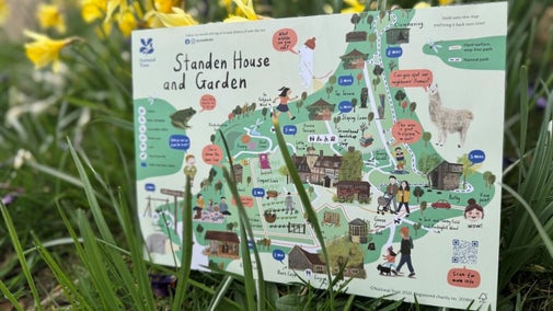
(Point 1 on map) Start at the gate at the lower (southern) end of the bottom car park. Turn left once through the gate onto the path enclosed by hedges.
2
(Point 2 on map) Continue along this path into the woodland keep right at the first footpath sign. As the path next divides by the 2nd footpath sign follow the left hand fork to Weir Wood Reservoir around the top side of a small pond.
On the way to Weir Wood reservoir
The hedgerow on the left of the path is fully established with native plants such as wild rose, hawthorn, elder and hazel. The newly forming hedgerow on the right allows views over the valley to Weir Wood Reservoir and Ashdown Forest beyond. This path probably follows the original Saxon field boundaries and is still used for driving cattle - and can be muddy!
3
(points 3 – 5 on map) Continue on this track walking downhill until you reach a stile at the bottom. Cross the stile into a field, keep left of field passing metal gates and head towards bottom of field. Climb the stile at bottom to meet the Sussex Border Path (not signposted) which skirts the reservoir. Turn right to walk along path.
Wier Wood Reservoir
Weir Wood reservoir, completed in 1952, is ahead. Much of the western end of the reservoir is a nature reserve and you can see some of the unusual birdlife living there. Look out for great-crested grebes with their elegant head bobbing dance, cormorants perched on the rafts spreading their wings to dry and, occasionally, osprey hunting during their migrations. When the water is low, wading birds can be seen hunting in the exposed mud.
4
(Points 6 - 7 on map) Keep ahead, passing a metal gate on the right hand side (6). Go over a plank bridge, pass a second metal gate on the right, continuing on the Sussex Border Path, cross a stile into the field keeping the chain link fence to your left (7).
Standen Farm
A path runs along the bottom end of Hollybush Wood. This woodland makes up part of the Standen estate. Much water drains through here and often floods the path. On the far side of the field to the right is an old barn, which is all that remains of the original Standen Farm, one of the three farms the Beales bought in the 1890s to form the Standen estate. This is remembered as a 'small, low-pitched cottage, inhabited by an enormous family'. It was demolished in 1896 and the name was adopted for the big house.
5
(Points 8 - 9 on map) Continue for 350 yards along the edge of the field. Cross a small wooden two-plank bridge and go through a small metal gate (8). Continue on the Sussex Border Path, with the chain link fence on your left, cross a stream and walk up to a metal gate. Go through the gate, turning right (before the public footpath sign) thus leaving the Sussex Border Path (9).
Standen Rocks
Standen Rocks, once used by the Beale children and grandchildren from Standen for picnic teas, on the right, are moss-covered sandstone outcrops close to the path. If there’s time, make a detour to explore them and the wonderful views they offer across the reservoir. In the Beales’ day, the view would have been very different, as the reservoir, fed by the River Medway, was not built until 1952.
6
Walk up the hill, keeping the wide, scrubby hedgerow on your right and crossing under the high-voltage power cables. Go through a metal gate by the two pointed finger post. The steeper headland path leads through more scrub (Please persevere in this area; the scrub can become very overgrown in summer.) At the top of the scrub footpath turn right by the three point public footpath sign pointing up the hill.
Views of Standen
The path here is sunken between deep banks, caused by the gradual wearing away of the surface by centuries of use and erosion. Soon there are good views back down to the reservoir on the right. Many of the fields here are relatively small and were probably carved in Saxon or Norman times from the great Andredsweald Forest which covered this area. Across these fields, Standen House comes back into view on the right.
7
(Points 10-11 on map) Continue walking ahead up sunken path past disused stile to a fence and metal gate. Go through gate continue ahead. At the National Trust gate and three point finger post continue ahead keeping the hedgerow/fence to your right hand side.
The Plantation
Most of the farmland around Standen is managed organically for grazing or for hay, and wildlife is always considered as part of the management. The top corner of the adjacent field has been allowed to grow with brambles and bracken, which provide a valuable habitat for different kinds of wildlife and nesting places for birds and small mammals.
8
(Point 12 on map) At the top corner of this field (12), go through the metal ’kissing gate’, continue along the path between the woodland and the barbed-wire fence until you reach Standen’s drive and a three way finger post.
Saint Hill Manor
Across the valley to the left is the 18th-century Saint Hill Manor. Previous owners have included the Maharaja of Jaipur and Mrs Neville Laskey, who allowed the manor to be used for wartime RAF officers who received treatment from Sir Archibald McIndoe, the world-famous plastic surgeon at Queen Victoria Hospital in East Grinstead. The hills in the far distance are Leith Hill and the North Downs.
9
(Points 13 - 14 on map) Turn right down the drive (13), you will pass cottages on your right, which leads back towards Standen (14).
Webb Cottages
The cottages on the right of the drive used to be lived in by estate workers, the first being designed by Phillip Webb at the same time as Standen House. On the right further down the drive are the large sandstone outcrops which were a mediaeval quarry, and which the Beales thought would make a suitable entrance to their new property at Standen. Just before the Standen gates, on your left, is the entrance to Jack and Tommy Field, which has been restored to a wildflower meadow.
End:
Standen car park, grid ref: TQ391356